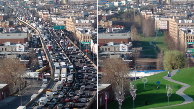
A New York City-based artist is rapidly transforming U.S. streets into walkable paradises with the help of artificial intelligence, and breaking down Americans' stubborn inability to imagine how their communities could be designed around people instead of automobiles.
Since launching a mere seven days ago, Twitter account @betterstreetsai has gone viral with its quick-and-dirty renderings of how auto-centric roads might be transformed into picturesque pedestrian plazas, generous cycletracks, and more, all made in minutes with the help of the artificial intelligence-powered illustrator DALL-E-2 — and yes, the account takes requests.
Here's one Streetsblog requested of Highway 19 in Pasco County, Florida, which holds the dishonor of being the single most deadly street in America for pedestrians — but could become an epic light rail corridor flanked by affordable housing and shared use paths, after a few edits.
US-19, "the deadliest road in America" (New Port Richey, Florida) pic.twitter.com/dZRsaALn83
— AI-generated street transformations (@betterstreetsai) July 27, 2022
While DALL-E-2 is certainly more internet-famous for generating dadaist images of muppets superimposed into dystopian action movies and Gordon Ramsay screaming at babies, the man behind @betterstreetsai, 28 year-old Brooklyn artist and safe streets advocate Zach Katz, has found it to be a powerful and efficient tool to demonstrate what the world could look like without so many cars — which he says many Americans struggle to do without a visual aid.
(Disclosure: Katz' Used Dutch Bikes company recently sponsored a series of articles on our sister site Streetsblog NYC, and we've featured his writing on Streetsblog USA before, but we had no idea he was behind the anonymous account when we approached him for an interview. Small world.)
Lake Shore Drive (Chicago, Illinois) pic.twitter.com/cQrBdd1bSf
— AI-generated street transformations (@betterstreetsai) July 27, 2022
"One of the biggest barriers to really effective street safety advocacy is just how expensive and time-consuming it is to make realistic, exciting, renders that have the wow factor and show people what’s possible," Katz said. "It's one of the most cost-and time-prohibitive things, but it's also the most powerful thing. Even Robert Moses said something like, 'You can talk and talk and talk about an idea and they won't care, but as soon as you show them a beautiful picture, they get excited.'"
NW 23rd Ave (Portland, OR) pic.twitter.com/tYBAMY3psc
— AI-generated street transformations (@betterstreetsai) July 24, 2022
Katz, who has no formal training in urban design, says his project began as a haphazard experiment focused on a handful of streets in the neighborhoods he knows best, and that he isn't systematic about selecting which sites to transform. Making the images requires little more advanced design work than taking a quick Google Street View screenshot, "erasing all the car territory" in the image, and feeding DALL-E some cursory prompts about what should replace it.
For those who'd like to experiment with DALL-E-2's less-powerful free version, Craiyon — the more advanced version Katz is using has a long waitlist and charges a fee, which he offsets with tips — Katz advises that long strings of sustainable transportation buzzwords like "European cobblestone promenade with ornate water fountain, children playing, benches, flowers, lots of greenery, and bike paths" seem to work pretty well.
N 8th St (Sheboygan, Wisconsin) https://t.co/oxEnpo9bAL pic.twitter.com/5iFExHRhGJ
— AI-generated street transformations (@betterstreetsai) July 26, 2022
Once his first few images were online, Katz was quickly inundated with more than 400 requests from people around the world. In addition to advocates, his patrons include policymakers like the mayor of small Wisconsin town, nonprofit groups who've long lobbied for specific, real-life street overhauls, and even residents of relatively people-friendly cities, like Eindhoven, Netherlands.
"So many of the streets in Holland are already so multimodal, but they still have this relentless desire to improve them," said Katz, who lived in Amsterdam for a six-month stint himself. "They’re actually trying to remove protected bike lanes — to turn the whole street over to biking and walking."
Emmasingel (Eindhoven, the Netherlands) pic.twitter.com/VRcE2Yynhv
— AI-generated street transformations (@betterstreetsai) July 25, 2022
Katz acknowledges that uncanny valley graphics of fuzzy light rail lines and creepy faceless internet ectomorphs on bikes aren't exactly the same as spec'ed-out professional renderings rubber-stamped by actual designers. (He does point out, though, that a fair number of built environment professionals follow his account, and Curbed's Alissa Walker argued that he's making a compelling case for "replac[ing] city engineers with bots.")
6th Street Viaduct (Los Angeles, CA) pic.twitter.com/7JwwlpcjPy
— AI-generated street transformations (@betterstreetsai) July 25, 2022
Still, Katz says that even the most rudimentary illustrations can help people imagine what's possible for their places — and without them, it can be hard to make the case for real-life changes to concrete-laden landscapes that seem like they're they to stay. And since, as he rightly points out, "not everyone's on Twitter," he hopes people will print out renderings like his and post them on the dangerous roads such designs might replace.
"Ultimately, change is only possible if you can imagine it," Katz said. "These images help us imagine what the streets could look like."
