New Tool Helps Planners and Public Visualize Vehicle Miles Traveled
Note: GJEL Accident Attorneys regularly sponsors coverage on Streetsblog San Francisco and Streetsblog California. Unless noted in the story, GJEL Accident Attorneys is not consulted for the content or editorial direction of the sponsored content.
Fehr & Peers has developed a new tool to help planner and the public "see" how much driving people do, both locally and regionally, in California. This is useful for planning, for grant applications, for estimating traffic impacts from projects, and for estimating greenhouse gases from transportation.
Back in the dark ages - still with us in some ways - planners got used to using a proxy when they had to estimate the environmental impacts of traffic from a project. That proxy was delay to drivers, which didn't make much sense - delay is not an environmental impact - but for some reason few noticed that little problem. Estimating Level of Service, or LOS, became a common planning practice, applied in many situations, whether called for or not.
Streetsblog has written a lot about this topic. The quick version of the story is that using LOS led to a wide range of unintended consequences, including a transportation system that supports and encourages car travel to the detriment of any other mode. After years of pointing out why this is a problem for everyone and the environment, wiser heads finally prevailed and the state began moving away from measuring delay and towards accounting for the actual impact from traffic - increased VMT, or vehicle miles traveled.
See here and here for more background. It's been a huge change, slowly coming to California.
VMT is simpler to measure than estimating LOS. The Governor's Office of Planning and Research offered a lot of guidance to planners; UC Davis developed a simple tool to help planners calculate induced demand from roadway expansion projects.
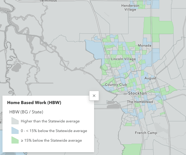
Now it's even easier. Fehr & Peers' VMT+ tool uses fine-grained, census-block-level data from StreetLight, a company that collects and manages up-to-date travel information from a wide variety of sources. The data focuses specifically on home-based trips and commutes. The tool is designed to help people visualize how much driving happens locally and regionally, and can be used to help estimate transportation impacts for land use plans and projects.
The tool offers some pre-formatted maps showing VMT per capita patterns all over the state. See the illustration above for an example from Stockton that compares commute trip lengths to statewide averages. But users can also create their own filters.
The tool developers emphasize that the data is not "independently peer reviewed," but Fehr & Peers and Streetlight continuously review the data themselves, and it is current, where many regional travel models rely on information that can be several years old.
In addition, "we hope others will review and provide us input so we can continue to improve and refine the tool," said Ronald Millam, Forecasting Practice Leader at Fehr & Peers.
More to come later. Meanwhile you can poke around on the website.

Streetsblog has migrated to a new comment system. New commenters can register directly in the comments section of any article. Returning commenters: your previous comments and display name have been preserved, but you'll need to reclaim your account by clicking "Forgot your password?" on the sign-in form, entering your email, and following the verification link to set a new password — this is required because passwords could not be carried over during the migration. For questions, contact tips@streetsblog.org.