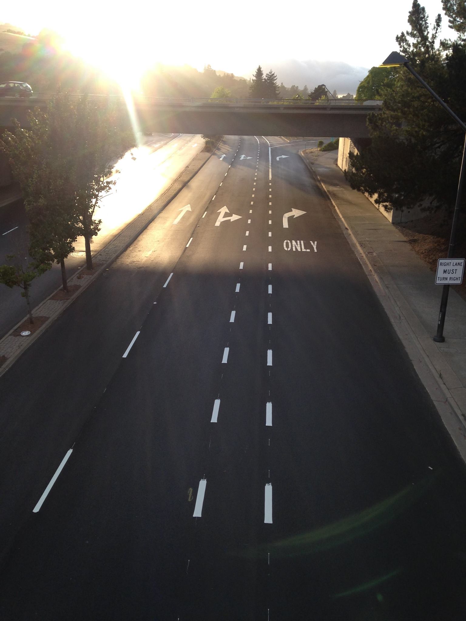
The title of this post may be a bit hyperbolic, but Orinda really deserves attention for this one-of-a-kind bike facility. As seen in the image above, a bike lane on Camino Pablo signals that bicyclists should go straight ahead—between two right-turn lanes that lead to a freeway onramp.
Yes, the right turn from the middle lane is optional—so there's no guarantee that a bicyclist will be right-hooked by cars heading onto the freeway. And the lines marking the bike lane are dotted, not solid, implying that merging is allowed, so bicyclists ought to be aware. And that spot where the line goes solid at the top of the image? It seems to serve as a reminder to bicyclists not to turn right—so they don't end up on the freeway.
But as for the "encouragement" value of the new lane...this bike lane is not going to encourage new riders to hit the road any time soon.
This project was meant to be an inexpensive solution to fixing a gap in the bike network. The underpass connects the Orinda BART station to popular bike routes in the surrounding hills. The street was slated for repaving, so city engineers decided to restripe it and add the bike lane. Beautifully buffered bike lanes lead to the underpass pictured above.
Across the street from where this photo was taken, there was no room for a bike lane, so Sharrows were added. Unfortunately, the Sharrows place bicyclists directly in the path of cars emerging from a freeway offramp.
Larry Thies, a city engineer who worked on the project, said the design was decided on after consulting with bicyclists who use the facility, and who currently ride where the lane is marked. “We thought [the striping] would bring more awareness by motorists to that area,” he said. “Before, there was no bicycle marking at all.”
The current solution is “not ideal at all,” he said. “We are working with Caltrans to eliminate the double onramp at that intersection. A lot of thought went into [the current design]. We are trying to better accommodate bicyclists in our community; we have a lot of commuters, but also recreational riders who ride through here, especially on the weekends.”
Local bike advocates at Bike East Bay and Bike Orinda had asked the city to convert the middle lane to straight-through traffic, thus eliminating the double right turn, and to add green paint to highlight the conflict areas, but those changes weren't made.
Thies told Streetsblog, “We're trying to improve it. Caltrans is very concerned about creating any backups from onramps onto city streets. The underpass is within Caltrans' jurisdiction.”
“We are evaluating it. I've received some feedback from people who really like it this way; others think it's a bad idea,” he said.
As for adding green paint to highlight the areas of conflict, Thies said, “We talked about it in a general sense, but aesthetically it would be a very hard sell in Orinda. We're not Berkeley or Oakland; Orinda is a semi-rural community, and it's not looking to make big changes. We're not prepared to put green bike lanes throughout Orinda.”
In other words, it's business as usual in this California city: car throughput and even aesthetics outweigh safety.
For Caltrans, this should be an easy call. With a stated goal of tripling bike mode share, the state transportation department should be willing to do whatever it takes to encourage new bicyclists—something that will not happen if bike lanes are like this one. As for concerns about slowing car traffic, that's not necessarily a bad outcome.
Engineer Thies even pointed out that car speeds at this spot on Camino Pablo are different depending on the time of day. “During commute hours, with a lot of traffic, it slows down,” he said. “During nonpeak hours drivers are probably traveling 40 to 45 mph, depending where they're going through this section.”
That is too fast for most bicyclists, especially potential bicyclists, to feel comfortable riding next to traffic.
“Eliminating the double right is probably the best step in the right direction,” said Thies. As for other traffic calming measures, “We already have quite a few signals through that stretch. And Orinda has a policy of no speed bumps on arterials.”
“The other option is a road diet. But it would be very difficult for me to propose that at this time. If you look at overall geometrics of that stretch,” he said, “it would be a very tough sell.”
Dave Campbell of Bike East Bay notes that some progress has been made since this lane was striped a few weeks ago. City engineers met with Bike East Bay and Bike Orinda, and have agreed to submit a project proposal to eliminate the second turn lane onto the onramp. That is, they agreed to propose that the work be included as part of the Measure J reauthorization. Measure J is a Contra Costa County transportation sales tax measure that will be on the ballot in 2016 and requires a two-thirds vote to pass.
Meanwhile Robert Prinz of Bike East Bay took some videos of what it's like to ride here, in case the image above isn't enough. You can see his northbound trip here, and his southbound trip here.
Prinz noted a few other interesting things on his ride. “Almost all of the northbound drivers heading to the freeway were choosing the rightmost lane, meaning that the middle right turn lane is extra unnecessary and that the Sharrows before that basically just end up backing up traffic while also endangering bicyclists. I was honked at by a driver while riding in the rightmost Sharrow lane, right on top of the Sharrows.”