Brown University Students Launch ‘Waze for Safe Bike Routes’
A software startup run by two seniors at Brown University aims to help more bike riders find better bike routes with a new navigation app that lets users rate streets along their way.
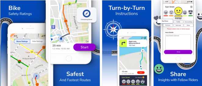
Last week, Brown University seniors Maggie Bachenberg and Trisha Ballakur launched their app, Pointz, on the Apple and Google Play app stores. They describe it as “Waze for bikes” – it’s a mapping app that offers turn-by-turn directions, but it also invites users to evaluate streets along the way to to inform future route recommendations for others.
When you download Pointz, it looks like a typical mapping app. But when you ask it for directions, Pointz will often suggest routes that follow low-traffic neighborhood streets, instead of more direct routes over busier roadways.
Once the turn-by-turn directions are activated, users have the opportunity to rate the streets along their way on a simple 5-point rating scale, ranging from  to
to  . After the ride, users are invited to provide more detail about their ratings, which influence the app’s future route recommendations.
Eventually, once enough users provide a critical mass of ratings, the Pointz map will show those ratings on the map. Over time, that data could help local planners and advocates pinpoint streets that could benefit from safety improvements, or identify gaps in neighborhood bike routes.
The idea for Pointz app emerged from some the founders’ coursework at Brown.
“I got interested in this space when I did a cross-country bike trip in my gap year, and when I got to college, I decided to do something entrepreneurial to encourage people to try biking,” Maggie Bachenberg told StreetsblogMASS this summer, when Pointz was still in beta-testing mode.
“Our main goal is to make it more enjoyable and safer for your average person to ride in American cities. Originally we wanted to do something that could improve infrastructure, but through the process of customer discovery we came to understand that infrastructure is pretty hard to change,” said Bachenberg. “So we decided to work more with what already exists. Our overall goal is to get more people on the road and help them find safer routes that feel comfortable.”

Streetsblog has migrated to a new comment system. New commenters can register directly in the comments section of any article. Returning commenters: your previous comments and display name have been preserved, but you'll need to reclaim your account by clicking "Forgot your password?" on the sign-in form, entering your email, and following the verification link to set a new password — this is required because passwords could not be carried over during the migration. For questions, contact tips@streetsblog.org.