In Davis, a New Bike/Ped Safety Project Is Blamed for Heavy Traffic

By Drew Hart
By Drew Hart
Note: GJEL Accident Attorneys regularly sponsors coverage on Streetsblog San Francisco and Streetsblog California. Unless noted in the story, GJEL Accident Attorneys is not consulted for the content or editorial direction of the sponsored content.

It seemed straightforward enough.

Wide, underused Mace Boulevard in Davis needed repaving. Its faint bike lane markings didn’t make the street feel safe for riding, especially to parents of students at the local elementary school, Pioneer. Over eighty percent of those students were driven to school, the highest percentage for any school in Davis.

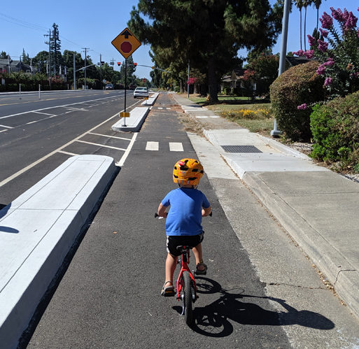
So the city changed it. Mace was repaved and vehicle lanes were reduced from two to one in each direction. A curb-protected cycle track replaced the faded bike lane. Right-turn slip lanes that encouraged fast, wide turns at the corner with Cowell were eliminated, replaced with a version of a protected intersection that featured wider crosswalks and pedestrian refuge islands.

Mace Blvd at Cowell. Old slip lanes have become bikeway; vehicles are forced to take the turn slowly. Photo by Drew Hart
Mace Blvd at Cowell. Old slip lanes have become bikeways; vehicles are forced to take the turn slowly. The city plans to remove the concrete islands closest to vehicles as soon as it can. Photo by Drew Hart

Planning took several years, beginning with a grant application to SACOG in 2013. Construction finally began at the beginning of the school year in 2018. That kept the road torn up for a long time, and by the time the project was finished last spring, patience had worn thin. The local NextDoor site was filling up with complaints, and the city held several workshops to update residents about the project.

The new configuration was completed before school let out for the summer, but just barely. Nevertheless, a count taken on Bike to School Day in May showed significant increases in students biking to school. Local parents like Drew Hart felt safer letting their children bike along the new lanes, now protected by a substantial curb from fast vehicle traffic on Mace.

But even Davis, whose reputation as the “bike capital” of California has faded like the former Mace Blvd bike lanes, is not immune to driver backlash.

Drivers complained about losing a lane; they complained about having to slow down to make a right turn; they complained that it was difficult to get in and out of traffic congestion on Mace. Mostly they complained about heavy traffic. They showed up angry at public meetings and shouted down opponents.

Hart, whose children go to Pioneer, went to one of the meetings to support the project, which he said has made the area much safer for his kids. City staff, he said, “were being yelled at.” He spoke out, saying, “My biggest concern is that all of these comments will cause the project to get ripped out. It’s been poorly managed, but it has merit.” In response, he said, “I got booed.”

This kind of backlash is nothing new for planners and designers and advocates of safer infrastructure, especially road diets; in fact it’s come to be expected that people get upset and complain about changes to the streetscape. Usually the right thing to do is let some time pass, so people get used to the new design, and to allow time to collect data on safety and any mode shifts that might occur.

But in this case the city is already planning to tear out some of the just-installed concrete, and is considering other changes that could eliminate the road diet, potentially reducing the bike-lane barriers and/or shifting the new bikeway. The plan is to remove the new concrete islands at the intersection at Cowell as soon as possible, preferably before school starts again in the coming weeks.

Mace Blvd at Cowell, before the redesign. Slip lanes allowed cars to make fast right turns. Image: Google Street View, 2016

In other words, the finished project won’t exist long enough to properly test whether it meets its primary goal, which, according to its grant application, is “to increase bicycling and walking to Pioneer.” The application specifies that:

A 2013 Safe Routes to School audit determined that a perceived lack of safety when traveling on or crossing Mace Blvd is a major barrier to parents allowing their children to walk or bike to school. Furthermore, a June, 2013, Open House for this project revealed neighborhood residents would walk or bike on Mace Blvd if speed concerns were addressed and bicycling safety and comfort were improved.

Meanwhile, the city has hired a team of consultants to weigh in on potential ways to change the new design to get vehicle traffic back to its original free-flow condition. According to Mayor Brett Lee, the hope is that they can begin reconstruction as soon as this fall.

He acknowledges that the timing is not great.

The problem is that the complaints about traffic congestion, while not utterly without merit, are scapegoating the long-planned bike safety project. When it was being conceived and planned, traffic on Mace Blvd. was light. No official traffic study was done, but existing traffic counts showed less traffic on Mace than on Fifth Street, where Davis had already built a successful road diet.

But between planning, design, and construction, circumstances changed. Traffic on nearby I-80, which cuts through Davis on its way between Sacramento and the Bay Area, had been growing steadily. This is especially the case on Thursday and Friday afternoons, when residents from the Bay Area and points south head to the mountains on weekend trips. In response, Caltrans had changed the meter timing at the Mace Blvd. on-ramp, slowing down the rate of vehicles entering the highway there.

And then came Waze.

Mace Blvd. is almost the last entry point onto nearby I-80 for drivers heading to Sacramento. East of Davis, the causeway on the Yolo Bypass is the only way across the wide Sacramento River flood zone for miles to the north and south. The causeway is a chokepoint, with traffic frequently backing up before it in both directions–which is a bit mysterious because it isn’t narrower than the rest of I-80, just raised up on a long bridge structure. Whatever the cause, the traffic backups can extend deep into Davis.

Waze gives drivers who wouldn’t normally know a way around that congestion alternatives via frontage roads and parallel county roads. The number of drivers getting off I-80 as far west as Dixon has been rising since the advent of Waze. County roads absorb them readily, but they all have to get back on the freeway before hitting the causeway–which means at Mace Blvd. Even if a driver wants to continue east to the very last possible on-ramp, right where the causeway begins, they first have to traverse Mace.

So local residents are complaining about traffic congestion that begins and ends far beyond their neighborhoods. Drivers are up in arms about the road diet because they can’t use what used to be excess lanes to get around that traffic, and the congestion is making everyone tense.

On busy afternoons, according to Mayor Lee, “traffic tops out at three times the normal counts; the new design cannot handle that traffic.”

“On Friday afternoons, to go the equivalent of two San Francisco city blocks in distance takes twelve minutes,” he told Streetsblog. “It literally is gridlock. People are mostly stopped, and they inch forward.”

Lee says he wants to meet the original safety goals of the Mace Blvd. project, but not at the expense of other users. “A sizable group of folks believe that to make things better for cycling, we need to make it worse for cars,” he said, but he doesn’t see it that way. Lee has spent a lot of time thinking about bike-friendly designs, and even took a group of city staff and a city councilmember to Holland to learn about Dutch road design.

“In Holland, there isn’t that kind of zero-sum thinking. In some places, maybe it’s necessary; but it’s not generally true,” he said. On Mace, “we were trying to design something better for bikes and pedestrians–and for cars. We want it to be equivalent to what it was for cars. I believe it can be done because there is a lot of width on Mace. There’s room for a decent sidewalk, for a decent protected bike lane, and for traffic lanes.”

Lee believes the new configuration on Mace is “clumsy, even from a bicyclist’s perspective.” He describes the curbs protecting the bikeway as excessive. “It’s literally as if somebody in Stalinist Russia declared that there will be bike lanes,” he said. “They’re there all right, you can’t miss them.”

Mace Blvd before. Image: Google Street View, 2016
Mace Blvd in its previous incarnation as a stroad. Image: Google Street View, 2016

But even if the new configuration were completely ripped out and Mace went back to its previous stroad design–which is not something the city wants to do–that congestion wouldn’t go away. Lee and the city council are considering some ideas to help with that, but it’s not clear whether they will be able to put them into play.

For example, they want to convince Caltrans to speed up the metering lights at Mace, so cars can proceed more quickly onto the freeway. But Caltrans slowed down those lights because the congestion on I-80 can’t handle the increased traffic.

They also speak of changing signal patterns on Mace south of town, to hold traffic on the county road and discourage drivers from choosing that route, or make it look less attractive on Waze. But that could cause other issues; traffic planners are concerned that an arbitrary red light might be ignored by drivers who can’t see the point of waiting when they can see no cross traffic. It also might not have much effect on Waze algorithms; a small backup on a county road would probably still look like a better bet than a major jam on the freeway.

It’s not an easy fix. There’s not a whole lot the city can do about traffic outside its boundaries, as made clear by a note from Davis police chief Darren Pytel, who led one of the recent contentious meetings about the project.

Pointing out that the city cannot restrict passage on its streets to city residents, he writes:

In interpreting the Vehicle Code, California courts have consistently recognized the State’s policy that the streets of a city belong to the people of the state, and the use thereof is an inalienable right of every citizen and that all persons have an equal right to use them for purposes of travel.

Which is, of course, the point of making those streets available, and useful, for local residents who want their kids to be able to bike and walk on them safely.

It’s disheartening that a project aimed at increasing biking and walking, and thus reducing at least some local driving, could fall victim to pressures to accommodate even longer highway trips that occur only at certain times.

40 thoughts on In Davis, a New Bike/Ped Safety Project Is Blamed for Heavy Traffic

  1. slip lanes are never ever warranted in any place where humans are expected to be out and about.

    slip lanes are a murderous dangerous design for city streets –

  2. Actually, the opposition to this project would do well to back off total elimination of the improvements and reach out. They have consistently called for total return to the original design, called for recall of all city officials (even though they aren’t city voters) used the all caps shouting techniques, and generally have tried to minimize support for the redesign. They see nothing good about it and that is why it has become so polarized. They say they “have nothing against pedestrians and cyclists” but leave out the sentiment “as long as it doesn’t affect my ability to drive somewhere in the minimal amount of time.” Unfortunately, they have become so emotionally tied to their anger that they seem to believe that compromise is out of the question even while they insist the cycling/walking community should compromise with their point of view. It is ugly.

  3. But KJ, that mean it will take 45 more seconds to get through that intersection. i don’t have all day, ya know.

  4. I would be interested to know how blind people would approach the problem of walking in unfamiliar territory. The ADA access ramp is necessary, so eliminating the ramp would not be a good solution even if the barrier weren’t there in the first place. This is an example of how the fanatic opposition to this project throws the ktichen sink at this project hoping everything or anything can be used against it. Nitpick it to death.

  5. Yeah I live there. It’s a terrible design, buses couldnt even safely make the turn. It was way overbuilt, it looks like the improvements are putting it in better shape. I bike and walk and take transit by the way.

  6. Yeah I live there. It’s a terrible design, buses couldnt even safely make the turn. It was way overbuilt, it looks like the improvements are putting it in better shape. I bike and walk and use transit btw.

  7. It is not the responsibility of streetsblog to give a completely unbiased assesment of a project. This is a website devoted to building cities that aren’t car dependant.

    Now, take your wall of a text back to whatever troll farm you come from.

  8. Did you notice the first picture on this article? The truncated cones for the blind in the ADA ramp tell them they are entering a crosswalk. But, the crosswalk is gone.

  9. That’s fine with me, and I agree. But you can’t just take them all out and think everything will be hunky-dory. That’s why you do a traffic study and figure out where a through-right shared lane is adequate and where a conventional right-turn lane is needed.

  10. Slip lanes allow cars to turn at speeds which are inherently dangerous for pedestrians and bicyclists… that is why they are being removed. Slip lanes don’t belong in cities, they come from freeway design.

  11. The elderly, disabled, families with children with a “long” commute (under 10-20 miles) are all generally capable of riding: bikes, electric bikes, trikes, “family bikes,” cargo bikes, etc. Look up images/articles for all those groups of riders. More “types” of people can ride bikes than drive cars, including children.

  12. This article is well balanced because it does not exaggerate. I was just out there on a Tuesday morning at 7:45 and again at 8:00am. No traffic. Empty. For whatever reason. So it is not six hours a day every day. It might be six hours a week. Why design your city streets around angry out of town commuters and cater to their needs?

  13. Sure seems like a waste of taxdollars if they’re going to rip it out so quickly and NOT allow for it to stay long enough to measure and determine whether it’s much safer for people that walk and bike. Honestly the officials should really just hold the line and let it stand to get a better sense of its impacts instead of reacting to the nonsense. I imagine that the traffic flow will take care of itself when people better understand its real outcomes.

  14. So let me get this right… In addition to a road diet, the city also removed slip lanes and expected all right-turning traffic to queue up in the through lanes? This isn’t rocket science, folks. Slip lanes usually exist for a reason. Intersections are the primary congestion points in roadway infrastructure, so add conventional right-turn lanes and call it a day. It is highly unlikely that additional capacity between intersections will make a difference, but in the event that this is the case, the issue can be easily addressed by prohibiting on-street parking on Thursday and Friday afternoons.

  15. That’s why we don’t force anyone to ride bikes. We just attempt to facilitate it with safe infrastructure so those groups you mentioned end up with less traffic. If the young, the able-bodied, and families with children with a short commute don’t have to drive, then it’s better for everyone else.

  16. I agree Marishka, very one sided. I wish there was notification and outreach to those who use it daily. Especially, before the 3 million dollars was spent on it. I have lived in two different neighborhoods in close proximity to Mace for the past 15 years. The road was safe for me and my family to bike, drive, and walk, but now has become unsafe for pedestrians, bikers, and motorists on an everyday basis. I love the bike friendliness of Davis, and I also need to drive my car at times. This road is now a parking lot due to the changes they have made.

  17. You are wrong about there being “0 accidents of any kind” before. This is easily queriable public data so it’s rather bizarre to lie about it.

  18. The problem is that there are too many cars. Do you want your future to be dominated by more traffic lanes and dangerous streets?

  19. Sounds like a badly planned, (“. No official traffic study was done”) badly executed, poorly -promoted protected bike lane project that has motorists up in arms. And as usual, Streetsblog dismisses motorists concerns. No surprise there.

  20. “Some local residents have to park 3 blocks away from their homes because they cannot get home.” + “residents look like they are not willing to put up with a minor inconvenience “

  21. Addressing some of the inaccuracies (and missing info) in this article …
    (1) The last picture in your article looks like there is a skinny bike lane next to an overgrown sidewalk. Leading readers to think “Oh, that’s not safe for kids!” But what they don’t say (perhaps didn’t know?) is that this photo is taken where the rural road enters the outskirts of town. The extra lanes begin a block earlier (where cars from two residential areas enter) and the bike lane is just for the road cyclists coming into town from the south. At this point, children are NOT riding on this side of Mace. The various residential areas off to the east and west have internal streets and connecting bike lanes to the north (toward school), and the sidewalk on the other (west) side of Mace is marked as a bike lane for kids heading north (to the intersection one can see in the distance of this photo). That sidewalk-riding and a change in speed limit (from 55 to 35 MPH) was put in place about 40 years ago — in response to a child’s death when he tried to cross Mace. No deaths have happened in that section since then. And with our crossing guards at Cowell signal light, THAT intersection was also safe for children coming and going to school.
    (2) The article says “[drivers] complained about having to slow down to make a right turn”. Actually, the problem where Cowell crosses Mace is that there is NO RIGHT TURN LANE AT ALL. So folks trying to turn east on Cowell are stuck behind cars waiting to get on to the freeway. If there were two NB lanes and the right-hand one was “right turn only”, that would certainly help a lot.
    (3) It says: “It’s disheartening that a project aimed at increasing biking and walking, and thus reducing at least some local driving, could fall victim to pressures to accommodate even longer highway trips that occur only at certain times.”
    There is a lot of biking and walking happening WITHIN the neighborhoods. Davis has great bike paths — even at the very edge of town here in south Davis. What I find disheartening is that the planners didn’t look at Mace as the AGRICULTURAL ROAD that it has always been. Hundreds of tomato trucks make thousands of trips up Mace, over the freeway, and on north to the rest of Yolo County. We need Mace to be wide enough for ag trucks and emergency vehicles to easily get thru. We need for our local Unitrans buses to be able to make the corner at Cowell and Mace without having to jump the curb because those bulged out boulder-covered islands are in the way.
    There are some good locations for “road diets” — Mace is NOT one of them.

  22. The article is NOT “well-balanced”. Not everyone is Davis in agreement as to how far to go toward “restoring Mace Blvd to it former hideous design”, but all of us agree that at least SOME changes are needed to allow local folks to go about their business. (And your label of “hideous” shows YOUR bias.) Finally, your suggestion to “adjust their schedule during those six hours per week” shows your lack of info. It’s more like 6 hours a DAY during the week and ALL DAY on Saturdays that we have to idle for 20 minutes to go three miles in to town. (And, no, I can no longer ride a bike.)

  23. Good post. I also wish the writers of this article had not jumped to the conclusion that Waze traffic is the only problem.
    Perhaps the writers didn’t talk to or know about other area residents (including bicyclists) who have more actual knowledge of the situation.
    If the writers got more info, might they revise their article?

  24. It doesn’t have to look good “good”. Better than the alternatives is all that matters.

    The other way to check, is when the road is jammed, what fraction of the cars on it are headed for the rate-limited ramp onto the interstate? If it’s most, and the road is just storing cars people up for that ramp, widening it won’t help, because the people headed for the ramp won’t move any faster than it lets them pass.

    I pass backed-up cars every morning (biking) on my commute, and the slow driving is always caused by intersections, not by a lack of lanes between intersections.

  25. FIRST: The usual preamble, which I shouldn’t have to keep restating but always seems necessary. South Davis residents don’t want to harm bicyclists or pedestrians or eliminate bike lanes on Mace. Many of us ARE often bicyclists and pedestrians and the presumption that we aren’t is both incorrect and annoying. We understand how WAZE and Google Maps (navapps) work and don’t need lectured about it. We also understand that navapps and I-80 congestion are part of the problem we’re living with on Mace. We understand that restoring Mace will not eliminate these problems, but restoring Mace will make it easier for residents to move around in and between their own neighborhoods and will allow navapps congestion to clear more quickly. No one that I have talked to has been vitriolic (and I’ve talked to and corresponded with a LOT of people in the last 7 months). I haven’t seen any vitriol on Nextdoo — plenty of exasperation and frustration, but no vitriol.
    According to City staff at the first community outreach meeting, planning for this project began in 2010 and the plan was completed in 2013. At this meeting they informed us that the design was a state-of-the-art Dutch design that they had traveled to Holland to see, but when pressed by residents who had just returned from living several years in the Netherlands who pointed out it was nothing like Dutch designs, they admitted that the City staff had created the design. The project began in 2010, the design was completed in 2013 (we were told), and installation began in 2018 and was completed in 2019; that is, the project was a bad design to start with and was obsolete when installed (and yes, installation took too long, but residents were aware that stuff happens and hoped the design would be an improvement).
    The City did not talk to or even consider the agricultural businesses of South Davis. The tomatoes are ripening. The tomato trucks from farms on South Mace will be queueing soon, up to 1000-1500 truckloads of tomatoes and assorted produce from late July to mid-October 24/7 until the harvest is over.
    Before the Mace Boulevard “improvements” we had intermittent congestion, but the old design allowed it to clear quickly. Now, NB Mace has blockaded residents in their neighborhoods for as long as 4 hours. Emergency responders have admitted that they would be unable to reach some neighborhoods during gridlock because this design does not provide anywhere for gridlocked vehicles to get out of the way. ADA access requirements have been ignored.
    What South Davis residents are strongly objecting to is that this is a very, very bad design. In the 10 years before the installation of this project, there were NO accidents involving pedestrians/bicyclists and vehicles on Mace. Since late March of 2019 residents have reported over 80 vehicle incidents and near misses. (Reported incidents from January to March have not been tabulated, but we’ll get to it.) Again, South Davis residents do not want the bike lanes ripped out. They want the NB and SB second lanes restored and channelized right turns (with button-controlled turn stoplights) added. They want the bike lanes redesigned so that they are safe for bicyclists, don’t trap debris, broken glass, and bicyclists; and they want the bike lanes to be logically designed.
    At the January meeting the City informed us that they were going to complete the project and we would learn to love it. South Davis residents have been testing this bad design for 7 months. We are not “scapegoating” this project because we wish to harm bicyclists or pedestrians. We are against it because this is a very, very bad, very dangerous design. There is plenty of “real estate” as the City puts it, to build a good design, and that’s what we want. Will it cost the City? Yes. Do they wish that South Davis residents would give up? Probably. But we won’t.
    The only reason there haven’t been casualties on Mace with this new design is that South Davis residents have been extremely careful. But sooner or later this design will cause one.
    The City broke Mace Boulevard, and South Davis residents want the City to fix it. We don’t want congestion on I-80 or navapps-caused congestion to be used as an excuse to not fix Mace.

  26. The traffic cannot look good on Waze now, and the backups are worse than before.

  27. I have lived in south Davis 21 years, and east of Mace for 8 years. I bike every day to and from work, and my son has biked across Mace to go to Montgomery, Emerson, and now the high school. I have never felt as unsafe on my bike until this year. I have almost been hit 3 separate times while obeying the lights at Cowell and Mace. That’s 3 more times than in the previous 7.5 years. While I bike a lot, I actually do drive (yes, it’s true). In trying to just go across Mace on a Cowell, with no right turn lane, it has taken 5 light changes of not moving to finally get in the left turn lane and drive through the neighborhood instead of just going straight. Our family is held hostage most any Thursday and Friday evening.

    I have a hard time understanding this article, especially with it starting out with “underused Mace”. What? Additionally, while I believe that we all should have a voice in this, the picture of the small boy on his bike says it all….no one else biking and debris all over the lane.

  28. They really ought to hold the line on the road diet. Adding capacity to satisfy Waze-induced demand will just result in a bigger, wider traffic jam; as long as the route looks good, traffic will be sent there.

  29. Your comment does not address any of the real concerns that husband failed design created. I don’t know whether you live here, but if you do you would acknowledge that its not just an “inconvenience” to drivers; it’s a hazard for bicyclists, which defeats its original purpose and which the City of Davis officials acknowledged at the publicly held meetings.
    On an unrelated note – forcing everyone to ride bikes and abandon cars discriminates against the elderly, disabled, families with children with a long commute, and other vulnerable groups of citizens.

  30. This is a well-balanced article, but will frustrate those who not only depend on auto transportation, but are either unwilling to adjust their schedule or, more sympathetically unable to adjust their schedule during those six hours per week when congestion is at its worst. This article lays out the limitations of engineering a solution. It’s excellent at listing the problems that will arise when any given “solution” is implemented without a deeper look. South Davis and El Macero residents have every right to be angry, but their vitriolic and zero sum game of restoring Mace Blvd to it former hideous design at everyone else’s expense has driven a wedge between them and everyone else who recognizes the complexity of the problem.

  31. This is an extremely one-sided article making South Davis residents look like they are not willing to put up with a minor inconvenience for the greater good of a prevailing majority’s of residents who suffered without these modifications. The article fails to mention real concerns of the local residents, from not even notifying them of changes, and where the city dropped a whopping $3 mil on a 2013 project without making car counts or accounting for a multitude of changes from 2013 to 2019. The project did not just make South Davis residents effectively trapped in their own neighborhood where they cannot take their kids to school or focus shopping. It made it impossible for an emergency’s vehicle to get to these homes. Some local residents have to park 3 blocks away from their homes because they cannot get home. In an emergency, where every minute counts, should they hope emergency response team will park and walk to get to them?
    Taking away a second lane and dedicated right turns made it impossible for local residents to get out of the way of the I-80 bound traffic. This created a hazardous situation where drivers make illegal u-turns, run traffic light, go into an oncoming lane to skip out of the only lane that’s congested with the I-80-bound folks, and speed through the Nugget parking lot and back roads trying to just get out or through. Maze traffic made things worse, turning residential streets into a speed ways. The project is not an”mere inconvenience”. The project created many many hazards, making it unsafe for all – bikers, pedestrians, and cars. Where there were 0 accidents of any kind with the original Mace design, there are now accidents. Police has to be constantly present. In this situation, most residents are scared to let their kids bike! There always was a bike lane and it’s was safer than it is now. So, please, if you write an article, try to give your readers a full picture, not a one-sided piece of writing to promote the agenda of those who are responsible for this failure of epic proportions.

Comments are closed.

ALSO ON STREETSBLOG