Caltrans District 4 Bicycle Plan: Meeting Tonight, Survey Ending
Caltrans District 4, which covers the nine counties in the San Francisco Bay Area, invites interested parties to attend a presentation on its progress towards creating a districtwide Bicycle Plan. The meeting, the third in a series, can also be watched online here, via Facebook.
The meeting will be held at the Berryessa Community Center at 3050 Berryessa Road in San Jose tonight, Tuesday, May 30, from 6 to 8 p.m.
The process of creating the plan started by collecting input through an online survey, which is open through the end of today.
At the meeting, Caltrans planners will talk about their work to identify and prioritize investments to improve bicycling on—and across—the state-owned parts of the transportation network. That includes many main streets that are officially state highways, such as 19th Avenue in San Francisco and San Pablo Avenue in the East Bay.
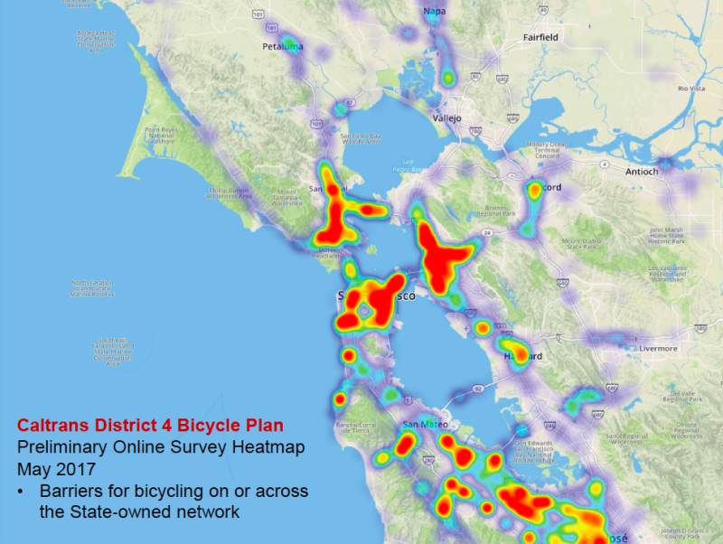
The presentation will include a summary of the responses so far to the online survey, which as of last week had received over 3,000 individual responses addressing over 19,000 places within District 4 that need work. The heat map above shows, in general, where those are.
Caltrans planners will then go over some of the data they have collected in the process of their bicycle needs analysis. That includes collision data, a travel demand model that studied all trips that could potentially be replaced by bike trips, and the level of stress bicyclists experience on the roads. Participants will be asked for their thoughts on which data is most useful and how it can be used to help prioritize investments.
All of this will be live-streamed online. Afterwards, in-person participants will attend an open house featuring preliminary maps of the results of the needs analysis. They will be provided with an opportunity to comment on specific corridors and barriers to safe and comfortable bicycling throughout the district.
People who can’t attend are encouraged to complete the online survey, which asks similar questions.
A summary of the workshops will be available in a future stage of the plan development.
The District 4 website has more information about the plan process here.

Streetsblog has migrated to a new comment system. New commenters can register directly in the comments section of any article. Returning commenters: your previous comments and display name have been preserved, but you'll need to reclaim your account by clicking "Forgot your password?" on the sign-in form, entering your email, and following the verification link to set a new password — this is required because passwords could not be carried over during the migration. For questions, contact tips@streetsblog.org.