New Bike Lanes on Yosemite Drive in Eagle Rock
The city of Los Angeles Transportation Department recently completed new bike lanes on Yosemite Drive. The 1.6-mile facility includes a mix of treatments: mostly conventional bike lanes and a block each of buffered bike lanes and sharrows (shared use markings). The new Yosemite bike lanes connect to existing ones on Eagle Rock Boulevard, extending a relatively robust bikeway network through this part of northeast Los Angeles.
Yosemite runs parallel to nearby Colorado Boulevard, one of the main commercial streets in the area. Yosemite is primarily residential, with several relatively large schools, including Eagle Rock High School.
The new lanes grew out of The Eagle Rock Association’s (TERA) initiative called Slow Yosemite. To address safety concerns along Yosemite, TERA worked with school principals, parent-teacher groups, the Eagle Rock Neighborhood Council, L.A. City Councilmember Kevin de León, and LADOT. In addition to bike lanes, the Slow Yosemite project added several new stop signs and some additional crosswalks.
The bikeway design includes more ambitious treatments where they can fit in street widths that vary quite a bit. In the past, the city sometimes would look at a street like Yosemite and just declare that a continuous bike facility was unfeasible. Today, with a supportive community and councilmember, and a more can-do LADOT, the street received appropriate upgrades – mostly standard bike lanes.
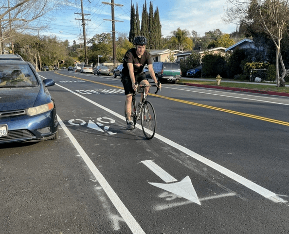
One narrow block – between Glacier Drive and Wiota Street – has just sharrows. One wide block – between Wiota Street and Avoca Street – has buffered bike lanes.
The western end of the facility features one of L.A.’s relatively rare asymmetric bikeways. For the 0.6-mile segment between Algoma Avenue and Eagle Rock Boulevard, there is not sufficient width to easily add two bike lanes, so the city put in a new uphill bike lane, and installed sharrows in the downhill direction.
Though this asymmetric treatment is fairly common in other cities, LADOT had been reluctant to install it on any significant stretches in Los Angeles.
The City Council recently approved a motion from Councilmember de León (council file 15-0719-S24) which called for piloting this uphill bike lane design. Streetsblog has noted that uphill-only lanes would allow needed bikeways to be installed on many narrow, hilly streets citywide, including in de León’s district on Avenue 51, Avenue 60, Avenue 64 and Townsend Avenue. Yosemite now serves as an L.A. City precedent for a design that can be used at appropriate locations throughout L.A.

Streetsblog has migrated to a new comment system. New commenters can register directly in the comments section of any article. Returning commenters: your previous comments and display name have been preserved, but you'll need to reclaim your account by clicking "Forgot your password?" on the sign-in form, entering your email, and following the verification link to set a new password — this is required because passwords could not be carried over during the migration. For questions, contact tips@streetsblog.org.