Eyes on the Street: New Coastal Rail Trail Segment in Santa Cruz
In December 2020, the city of Santa Cruz opened a new segment of rail trail. It’s not news today to Santa Cruz residents, but Streetsblog recently visited the new bike/walk path and offers this short piece celebrating the bikeway, and exploring a few features that may be applicable to facilities everywhere.

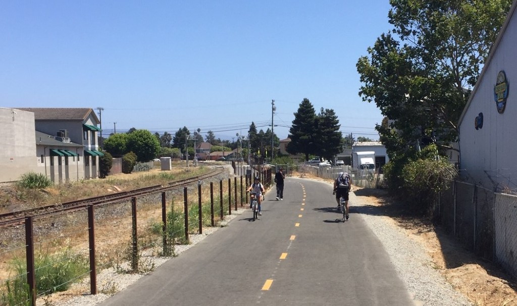
The new 1.2-mile stretch of Santa Cruz Coastal Rail Trail walk/bike path extends 1.2-mile – from Natural Bridges Drive to Bay Street. It is located just west of downtown Santa Cruz, extending through a residential neighborhood and a commercial/industrial one.
Trail project design and construction cost $9 million.

The new path is a small portion (officially phase 1 of segment 7) of a larger proposed Monterey Bay Sanctuary Scenic Trail Network.

The newly opened section runs alongside part of a 32-mile stretch of train track which extends from Watsonville to Davenport. The right-of-way had been under consideration for possible passenger rail; the bikeway does not preclude future rail in the corridor.
The new path has all at-grade crossings – ten in just over a mile. Through the commercial area and at several residential cross streets, the Rail Trail features “crossbikes” – essentially bright green-striped crosswalks that allow cyclists to continue riding without interruption. The ten at-grade crossings come fairly frequently, so cyclists need to negotiate with car traffic on perpendicular streets. For the most part, these are very low volume residential streets.

At one residential street that sees less car traffic and where the tracks cross at a narrow angle, there is one sharrow-ed crossing.

At Bay Street, the end of the facility near to downtown, the facility includes two blocks of two-way protected bike lane.


The city has plans to extend the trail further into its beachfront area next to its downtown.

In the beachfront area, the trail will connect with existing protected bike lanes on Beach Street. From there, the bikeway extends over the existing San Lorenzo River rail bridge, which is already converted to a rail trail for walking and bicycling.

Via a block of bike lanes, the west end of the new Coastal Rail Trail connects to an additional mile and a half long bike path, parallel to Highway 1, into Wilder Ranch State Park.

Below is the video of the December 10, 2020, ribbon-cutting for the new portion of the Santa Cruz Coastal Rail Trail.

Streetsblog has migrated to a new comment system. New commenters can register directly in the comments section of any article. Returning commenters: your previous comments and display name have been preserved, but you'll need to reclaim your account by clicking "Forgot your password?" on the sign-in form, entering your email, and following the verification link to set a new password — this is required because passwords could not be carried over during the migration. For questions, contact tips@streetsblog.org.