Caltrans and Metro Break Ground on 71 Freeway Widening Through Pomona
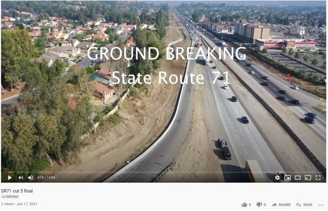
Today Caltrans and Metro celebrated a groundbreaking for a project to widen State Route 71 through Pomona. There was no on-the-ground groundbreaking, just a virtual one – a video posted to YouTube, featuring Caltrans District 7 Director Tony Tavares and a host of area elected officials. The SR-74 project will convert about 3.5 miles of existing four-lane expressway into an eight-lane freeway. Construction for the first phase – $174 million for just under two miles – is expected to complete in 2024.
[Note: at press time, Caltrans informed Streetsblog that the video had been taken down for corrections and will be reposted soon. For now SBLA left this article intact; if any Caltrans corrections change information referenced here, SBLA will revise this article.]
On today’s video, Tavares touted the 71 widening project in glowing terms: “expands the vast multi-modal network,” “improve[s] travel demand management,” “advances Caltrans’ goals of equity and livability,” “support[s] vibrant livable places,” and puts “a focus on addressing the needs and concerns of underserved communities.”
But it looks pretty much like any old-fashioned freeway widening project: tearing out homes, adding more lanes, more congestion, more pollution, more noise, and more global warming.
It’s difficult to find much information on the SR-71 widening project. The project does not appear on the Metro Highway projects webpage nor does it appear on the Caltrans District 7 Current Projects webpage. Digging deeper into these websites, the project does appears on some lists and in some presentations. There is a Metro factsheet dated August 2020, though it appears to be years out of date; it states that “SR-71 operates as an expressway with several at-grade intersections including Mission Boulevard” which is no longer the case.
According to a statement that Metro Highway Program Director of Engineering Victor Gau made in the groundbreaking video, the project’s “final Environmental Impact Report was completed in 1989.” From the state registry, it appears that there were additional/new environmental documents prepared in 2002. Streetsblog couldn’t find any of the environmental documents posted online.
Widening the 71 was included in Metro’s 2016 Measure M sales tax expenditure plan, which programs $248.5 million for a FY2022 groundbreaking and an anticipated FY2026 opening. The project also received $43 million in state S.B. 1 gas tax funding.
Much of the widened right-of-way was already taken a while ago, with homes already demolished, but there appear to be some additional homes that may be demolished for this phase of the project.
Along the 71 near Mission Boulevard, numerous homes were already demolished.
Metro staff have claimed that this SR-71 project is not widening, but just a gap closure.
A lot has changed at Metro and Caltrans since the 1980s (when Metro didn’t yet exist), but this project has remained on the books, and will soon exist on the ground.

Streetsblog has migrated to a new comment system. New commenters can register directly in the comments section of any article. Returning commenters: your previous comments and display name have been preserved, but you'll need to reclaim your account by clicking "Forgot your password?" on the sign-in form, entering your email, and following the verification link to set a new password — this is required because passwords could not be carried over during the migration. For questions, contact tips@streetsblog.org.