Skip to Content
Streetsblog California home
Log In
Streetsblog LA

LADOT Seeking Input on Low-Stress Travel Corridors in Central Los Angeles

3:03 PM PDT on September 24, 2020

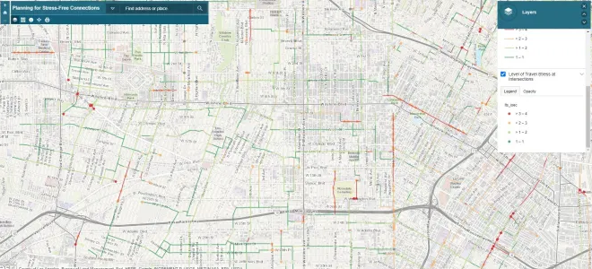
map of low stress streets in LA

The L.A. City Department of Transportation (LADOT) is developing a mapping tool that can help identify low-stress corridors primarily to bicycle, but also to walk, scooter, etc. LADOTs Planning for Stress Free Networks project is seeking public input on low-stress corridors - e.g. streets people already use and barriers to creating a more extended, more functional low stress bicycling network.

The project focuses on central Los Angeles, so it does not yet include the Valley, Westside, or Harbor areas.

Based on community input and professional analysis, LADOT has developed its preliminary low-stress map. Generally greener colors represent lower-stress street segments and intersections; orange and red represent higher stress.

Dark blue-gray spots show high-priority intersections
Dark blue-gray spots show high-priority intersections. This detail of 4th Street (through Hancock Park) shows dark gray dots meaning high potential for improvements at Highland Avenue and Rossmore Avenue intersections

Dark blue-gray and light gray dots show high-priority intersections. Improvements to some of those seen above would significantly reduce stress on what are otherwise already low-stress corridors. Over time, the maps are intended to inform LADOT project siting, such as where fixing a short gap can complete an extended low-stress corridor.

For more information, read the project announcement or project fact sheet, view the map, or watch LADOT's stress free connections webinar on YouTube.

Give LADOT your input on this project. Take an online survey and/or email ideas and feedback to stressfreeconnections(at)lacity.org. Feedback can include recommended informal corridors that bicyclists use and/or barriers to using low-stress corridors.
Stay in touch

Sign up for our free newsletter

More from Streetsblog California

Caltrans Readies Guidance for Complete Streets, with a Big Exemption

But somewhere along the way, highway interchanges - roads crossing and going under and over freeways and highways - were exempted from the guidelines

September 29, 2023

Guest Opinion: Ten Years In, CA Active Transportation Program Lays Bare a Tale of Two Agencies

L.A. County needs to embrace physically-protected bikeways, robust traffic calming around schools, and similarly transformative, safety-focused projects

September 29, 2023

Commentary: Let’s Talk About the Real “Fatal Flaw” on Valencia

How many people have to die before professional advocates stop endorsing the Valencia Street "experiment" on people?

September 29, 2023

Friday’s Headlines

Caltrans, we need complete streets everywhere, including at freeway interchanges (or maybe especially there); Public agencies and academics join forces to develop AV standards; Republicans really want to suspend the gas tax; More

September 29, 2023
See all posts