High-Speed Rail Central Valley Director Diana Gomez on Bakersfield-Palmdale Section Plan
California is building high-speed rail. More than a hundred miles are already under construction in the Central Valley – roughly from Bakersfield through Fresno to Madera. Planning is underway for the remainder of the statewide HSR network’s Phase 1, which will connect San Francisco to Los Angeles and Orange Counties.
The California High-Speed Rail Authority recently released its draft plan for connecting high-speed rail into L.A. County. The planned Bakersfield-Palmdale Section will extend about 80 miles across the Tehachapi mountain range.
To help readers understand more about HSR plans from Bakersfield to Palmdales, SBLA interviewed Diana Gomez, the CAHSRA’s Central Valley Regional Director. Gomez oversees of the high-speed rail corridor between Merced and Palmdale. The interview took place over email last week.
Streetsblog: Could you give a short status update for the CAHSR project statewide? What is already under construction? And what further planning is underway?
Diana Gomez: Approximately 119 miles of construction is underway in the Central Valley from Avenue 19 in Madera County to Poplar Avenue in Kern County. There are currently thirty active construction sites along the corridor where construction crews are building viaducts, overpasses, and pergola structures.
A significant number of utility relocations are also taking place to relocate and improve water and sewer infrastructure, as well as gas and electric lines. Each of our contractors are coordinating with several utility companies and public works departments to relocate these facilities. More information on each construction site can be found here.
In addition, the Northern and Southern California project segments are preparing Environmental Impact Reports/Environmental Impact Statements (EIR/EIS) before significant construction work can begin. More information on these project segments can be found here.
Please give readers some description of the Bakersfield-Palmdale section: how many tunnels, aerial structures, etc. and for what distances? What is likely to be the most iconic visible infrastructure for people in the three counties the project travels through?
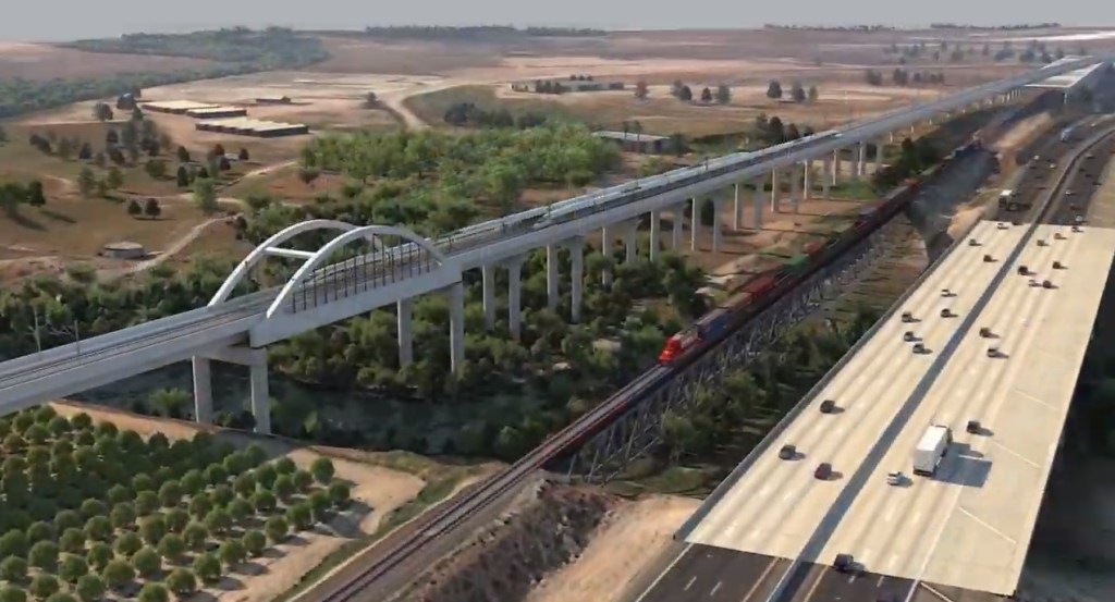
The Bakersfield-to-Palmdale Project Section is approximately eighty miles in length and traverses valley, mountain, and high desert terrain, as well as urban, rural, and agricultural lands. From the north, this project section begins at the Bakersfield Station and travels south and southeast through the Tehachapi Mountains, then descends into the Antelope Valley where it terminates at the Palmdale Station in the south.
The Bakersfield-Palmdale Build Alternatives would use five different track sections. These track sections would have varying profiles: surface tracks are low and near the ground, higher tracks are elevated or on fill (earth), and underground tracks are in a cut or tunnel.
The alignment across the Tehachapi Mountains utilizes a maximum gradient of 2.8 percent. There are nine tunnels. The longest tunnel is approximately 2.5 miles in length. For the preferred alternative, the total length of all nine tunnels is 10.75 miles. There are 15.25 miles of aerial structure. For people driving on SR 58, the most visible structure will be the viaduct that crosses over the freeway and Tehachapi Creek just northwest of Tehachapi. There will be places where it will be possible to see the Tehachapi Loop and the HSR alignment from the same vantage point. The HSR alignment will also pass by the Willow Springs Raceway in Rosamond, where spectators will be able to compare the speed of the race cars with the speed of the trains. The bridge over Caliente Creek just east of Bakersfield would also have the potential to be an iconic structure.
The Bakersfield-Palmdale Draft Environmental Impact Report/ Environment Impact Statement shows a preferred alternative and several other alternatives that were under consideration in some areas. Why was the preferred alternative chosen over others?
Preliminary analyses indicate the Alternative 2 Design Option strikes the best balance between the project’s objectives and minimizing or avoiding effects on environmental and community resources.
Staff believes Alternative 2 is preferable because it would avoid or minimize effects on resources, schools, disadvantaged communities, agricultural facilities, and mining facilities. In addition, Alternative 2 is more constructible because it:
- Would not require relocation of SR 58 or realignment of Sierra Highway;
- Would have fewer miles of tunnel construction; and
- Would have the fewest number of grade separations with local roadways.
CAHSR has been studying Bakersfield-Palmdale for over a decade. What’s new in this DEIR/EIS? Anything unexpected or interesting?
Since 2005, the Authority has continued to work with community and agency stakeholders to vet the conceptual alternatives and to refine the project design, gathering and evaluating additional environmental information and comparing the alternatives. As a result, six alternatives were introduced. Since that time, the Authority has continued to refine [them] in response to input from stakeholders, as well as improving the degree to which the alternatives meet the Authority’s objectives and the purpose and need for the project.
Currently, four alternatives are evaluated in the Draft Bakersfield-Palmdale EIR/EIS.
There are many earthquake fault lines all over California. Is earthquake safety a significant issue for Bakersfield-Palmdale? What is CAHSRA doing to make sure train riders are safe during earthquakes?
California has numerous active faults throughout the state that are known to produce large earthquakes. To ensure that the high-speed rail system can operate safely in such a seismically-active area, the Authority will implement a comprehensive seismic safety program, including earthquake early-warning and appropriate operational responses.
The infrastructure that will support the high-speed rail program – such as bridges, tunnels, high-speed rail stations, and other facilities – will be built to meet all state standards for earthquake design in California.
Please describe the Palmdale Station plans. What features and amenities are planned there?
Please refer to section 2.3.3 Stations for more information on HSR station design.
HSR stations will likely have many of the same amenities found at airports, including restaurants and retail spaces. Connections to other transportation modes, such as rental cars, ride sharing, local buses, the Palmdale Airport, and the train to Las Vegas will be available from the Palmdale Station. The Authority is working with the City of Palmdale to develop specific plans for the area around the station.
The projected Bakersfield-Palmdale cost – $18 billion for 82 miles – is less expensive than building or widening a highway. This stretch of HSR will cost about $220 million per mile, which is way less than the average Caltrans/Metro highway widening projects in L.A. County (North L.A. County 5 Freeway widening is about $100 million per mile, South L.A. 5 Freeway widening is about $270 million per mile, and lower 710 Freeway widening is about $400 million per mile.) Nonetheless, $18 billion is still a lot of money. What contributes to the high cost? What has the HSR authority done to contain costs?
The HSR alignment will provide significantly more capacity than those highway projects, which are typically only adding one or two lanes to the freeway. Factors that affect the cost are the need for tunneling and the extensive earthwork that will be required in the mountains. After environmental clearance is obtained, additional geotechnical investigations in the mountains and engineering refinements throughout the section are expected to lower the cost somewhat.
Is the authority considering any phasing for Bakersfield-Palmdale? Would it be possible to build any shorter tunnel segments early to allow some kind of shorter-term, intermediate service using existing tracks to get some kind of interim blended L.A.-Bakersfield passenger service going sooner? Say by building a tunnel that bypasses the Tehachapi loop, that would later be used by HSR, but could be used by Amtrak in the short term to open up a one-seat ride from L.A. to the Central Valley?
Currently the goal is to obtain environmental clearance for the entire eighty-mile long section. The need for phasing will depend upon the level of funding available for construction. Several options could be feasible, including the one cited in [your] question, but the Draft EIR/EIS assumes that the entire section would be constructed in one phase.
How can the public learn more about the Bakersfield-to-Palmdale section? How can people give input on the project?
The public can view the Bakersfield-to-Palmdale Draft EIR/EIS on our website or by visiting several depositories listed here.
The public has several options to submit a comment:
- Online via the Authority’s website
- Via email at Bakersfield_palmdale@hsr.ca.gov with the subject line “Bakersfield to Palmdale Draft EIR/EIS Comment”
- Via mail at the address below:
Attn: Bakersfield to Palmdale: Draft EIR/EIS
California High-Speed Rail Authority
770 L Street, Suite 620 MS-1
Sacramento, CA 95814
What are the next steps to connect California High-Speed Rail further into L.A. and Orange Counties?
We continue to move forward with environmental reviews in the Southern California region. In addition to the issuance of the Bakersfield-to-Palmdale document, we anticipate issuing the Draft Environmental Impact Report/Environmental Impact Statement for the Burbank-to-Los Angeles project section this spring, with the environmental documents for Los Angeles-to-Anaheim and Palmdale-to-Burbank later this year. In addition, we just wrapped a series of three informational public online meetings in Southern California today that talked about the upcoming work that needs to be done in the Burbank-to-Los Angeles corridor and get people prepared for the forthcoming document.

Streetsblog has migrated to a new comment system. New commenters can register directly in the comments section of any article. Returning commenters: your previous comments and display name have been preserved, but you'll need to reclaim your account by clicking "Forgot your password?" on the sign-in form, entering your email, and following the verification link to set a new password — this is required because passwords could not be carried over during the migration. For questions, contact tips@streetsblog.org.