Last Saturday, Los Angeles City Councilmember David Ryu hosted a neighborhood meeting on possible safety improvements for Sixth Street from Fairfax Avenue to La Brea Avenue in the Mid-City West area. The one-mile stretch of roadway runs along along the north side of the L.A. County Art Museum and along the south side of Park La Brea. This part of Sixth Street is a block north of two under-construction Metro Purple Line Subway stations on Wilshire at Fairfax and at La Brea.
For about a half-mile, especially between Hauser Boulevard and Fairfax, Sixth Street widens significantly. Along with the wider lanes comes increased speeding and increased crashes, injuries, and deaths.
According to the city, this stretch of Sixth Street saw two traffic deaths in 2016. At Sixth and Hauser, a cyclist was killed on September 1. At Sixth and Ogden Drive, a pedestrian was killed on August 10. On July 11, 2012, a particularly gruesome incident saw a morning driver jump the curb and kill a pedestrian by crushing her against a building. Herbie Huff, a city planner and resident of this area, says that "it's glaringly obvious to anyone who lives here that this street is awful and needs to change. We hear cars crashing all the time, and find the leftover pieces of glass and metal the next day after the wreckage is cleaned up."
SWITRS data, mapped above, show numerous serious collisions all along the corridor.
For several years, the Mid-City West Community Council (MCWCC) has been pushing the city of Los Angeles to make this stretch of Sixth safer. MCWCC worked with LADOT to propose safety improvements, including a road diet. The 2016 MCWCC-approved plan was also supported by the Park La Brea Residents Association, La Brea Hancock HOA, Greater Miracle Mile Chamber of Commerce, and L.A. Walks.
To date, the MCWCC plan has barely been acknowledged by Councilmember Ryu. Ryu expressed skepticism about road diets, asserting (minute 3:00) that road diets are "creating traffic" so "be careful what you ask for" but stated that (minute 32:00) despite "unintended consequences" he would study and "consider" the neighborhood council's Sixth Street road diet plan.
At Councilmember Ryu's neighborhood meeting Saturday, two options were presented for this portion of Sixth Street:
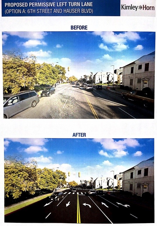
- Option A - New Left Turn Pockets. This option would remove some on-street parking to add left-turn pockets at La Brea and Hauser, and to add capacity to the existing westbound left-turn pocket at Fairfax.
- Option B - Road Diet. This option is very similar to the MCWCC plan. The road diet would eliminate a travel lane in each direction, adding a continuous left-turn lane allowing for easier left turns at La Brea, Detroit Street, Cloverdale Avenue, Cochran Avenue, Dunsmuir Avenue, Burside Avenue, Ridgeley Drive, and Hauser. The consultant's (Kimley-Horn) maps showed the road diet taking away a half-dozen blocks of on-street parking (this was disputed by locals, see below).
A questionnaire was distributed for attendees to express their preferences, though the survey did not match the options presented. The survey did not include option A or B, nor did it include bike lanes, the road diet, nor the road diet's left-turn pockets. The survey asked attendees to respond yes/no to numerous continental "zebra" crosswalks that are standard for the city of L.A. - something which is a bit like asking whether folks support having all three colors in a traffic signal.
Hard to judge whether people support bike lanes when you don't even ask them if they do pic.twitter.com/mOyBzPjzOr
— Michael. (@topomodesto) October 21, 2017
Mid-City West Community Council leaders and livability advocates expressed a great deal of skepticism about the forum, the survey, minimal attendance, errors in the presentation boards and the plans presented.
Advocates displayed a sign urging "best practices over best politics."
According to MCWCC board chair Scott Epstein, the road diet would remove only four to six parking spaces between Dunsmuir and Cochran; these are to connect to Cochran so that cyclists can transition to 4th Street. According to Epstein, the road diet would yield "a net gain in parking" by removing peak-hour and daytime parking restrictions. Per Epstein, the MCWCC plan would remove current 7 a.m. to 7 p.m. restrictions for three blocks from Cochran to La Brea, and remove current peak-hour parking restrictions for two blocks from Ridgeley to Dunsmuir.
Epstein criticizes Option A, stating it "sacrifices a ton of parking in a neighborhood that is demanding more, not less parking."
MCWCC board member Mehmet Berker further comments that the consultant's maps did not make clear the implications of adding a left-turn pocket from eastbound Sixth onto northbound La Brea. According to Berker, LADOT staff told him that "[LADOT] wouldn't want to do the La Brea left-turn pocket unless they extended the road diet configuration east past La Brea... so their Option A configuration showed new turn pockets at two intersections where there'd be one." With La Brea in question, Option A would add left turn pockets at only one intersection: Hauser.
Ryu has said that he makes it a priority to listen to communities in making his decisions. The next steps toward Sixth Street safety are in his court.
