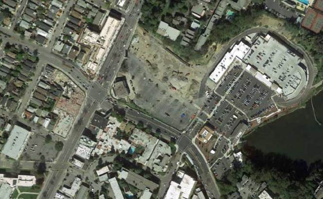
The intersection of 51st/Pleasant Valley and Broadway in north Oakland lies at the confluence of three of Oakland’s most walkable and bikeable districts – Temescal, Rockridge, and Piedmont Avenue – adjacent to Oakland Technical High School, California College of the Arts, and several senior housing complexes. Yet, it has always been a barrier to connecting these districts and destinations. Recent construction at three of the four corners of the intersection presented a unique opportunity to create a safer and more inviting area while filling the void left by a previous generation of auto-oriented strip malls. The Shops at the Ridge, a 300,000 square foot, 1,000 parking space development which redeveloped the Safeway/Longs Drugs complex on the northeastern corner, could have been the centerpiece of this revitalization. However, due to a lack of vision coupled with mismanaged implementation, the 51st and Broadway area has become even more of a mess today than it was before.
The Shops at the Ridge has brought a series of design missteps to the 51st and Broadway area that have exacerbated already challenging walking and biking conditions. The developer (TRC) and the City’s design review staff has ignored best practices and its own required mitigations to produce some truly unfortunate outcomes:
1. Inaccessible Pedestrian Crossing: At the project’s main entrance at Pleasant Valley and Gilbert, a traffic signal pole obstructs crosswalk access adjacent to a senior housing complex. Pedestrians must push a poorly located beg button and walk into oncoming traffic to cross the street – an especially dangerous situation for walker and wheelchair users or visually-impaired pedestrians.
2. Omission of Planned Bicycle Path: During the environmental review process, commenters raised concerns that the project would adversely affect bicycle conditions by failing to accommodate bicyclists traveling through the site (many bicyclists ride through the area to avoid the traffic volumes and grade change at the intersection of Broadway and 51st/Pleasant Valley). Master Response 7 of the FEIR provides an updated site plan that responds to these concerns, including an addition of bike lanes on Coronado and a two-way bike path along Gilbert. But as Robert Prinz of Bike East Bay has chronicled on Twitter, instead of constructing the agreed-upon bike path, the developer planted some palm trees – and the City let it slide. Bicyclists must now fend for themselves along the five lane driveway or sidewalk.
3. Bikeway Design Inconsistent with Design Standards: If there’s one thing that engineers, planners, and advocates can agree upon, it’s the danger encountered by a bicyclist passing a right turning vehicle on the right. AASHTO, NACTO, and Caltrans design manuals state that bike lanes should be placed on the left of right turn lanes to avoid potential right hook crashes. Unfortunately, the project’s Coronado Avenue driveway onto Broadway ignored this standard, instead directing bicyclists into drivers’ blind spot.
4. Auto-Oriented Design: Rather than building a walkable, mixed-use, transit-oriented development that helps address Oakland’s critical housing needs, the project essentially repeats the previous shopping center design while supersizing the site’s parking and supporting street infrastructure. The project added about 50 percent more retail and parking, which is therefore expected to induce additional traffic congestion. Because the City approved the project under its previous automobile Level of Service (LOS) standards, the project was required to widen streets like Pleasant Valley, adversely affecting walking and biking. If the project was reviewed under the City’s current vehicle miles traveled (VMT) standards, such widenings would be unlikely to occur.
5. Lack of Construction Coordination: With three of the four corners of 51st and Broadway simultaneously under construction, the intersection has been a mess. Beyond the frequent traffic signal outages and sidewalk closures, there have even been instances where as many as three of the four crosswalks have been simultaneously closed. The City’s lack of leadership in coordinating construction efforts to ensure safe circulation is disappointing; a better effort is needed for subsequent projects.
The Shops at the Ridge is a case study in planning and engineering mishaps. It’s a shame to see a site with so much potential not reach its highest and best use (mixed-use with housing) while simultaneously wreaking havoc on the surrounding transportation network. Whether the project will succeed from a financial standpoint remains to be seen: Oakland needs retail, but strip malls across the country are failing due to competition from online retailers and resurgent independent restaurants. Regardless, hopefully the pedestrian and bicycle issues at the Shops at the Ridge can be swiftly addressed to minimize risk of collisions.
This guest post was written by the staff at GJEL Accident Attorneys. GJEL is a sponsor of Streetsblog San Francisco.
