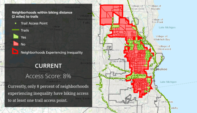
A new report from Rails-to-Trails Conservancy spotlights how disadvantaged neighborhoods in Milwaukee have less access to safe bicycle routes than other parts of the city.
Neighborhoods with high concentrations of poverty are often left out of planning decisions, but quantifying the impact of inequitable access can sometimes be difficult. Here's how Rails-to-Trails did it.
First, they identified desirable routes for bicycling by mapping multi-use trails, on-street bicycle lanes, and other streets that have a speed limit no higher than 25 mph and two or fewer lanes of car traffic. The organization then came up with a connectivity score that measures how easy it is to use this network for trips between residential parcels and destinations like grocery stores, pharmacies, banks, and post offices. The score also takes into account other factors, such as elevation, barriers like interstate highways, and the locations of traffic signals to help people cross high-stress routes.
Four in 10 Milwaukee residents lack good bike routes that can connect them to grocery stores, schools, libraries and hospitals within two miles, Rails-to-Trails found, while six in 10 lack routes to get to an employment center within the same distance.
Naturally, Rails-to-Trails is focused on access to trails, such as the Oak Leaf Trail and Hank Aaron Trail in Milwaukee. The organization considers a place to be connected to a trail if there is a low-stress route between the two less than two miles long, while a place is walkable to a trail if the route is less than a half-mile. Citywide, 24 percent of Milwaukee residents have bikeable access to a trail, and eight percent have walkable access to a trail.
But access is worse for low-income communities of color, which Rails-to-Trails defined as neighborhoods with high rates of poverty, unemployment, people without high school diplomas, and zero-car households that also have large African American and Hispanic populations. In these areas, just three percent of people are within walking distance and eight percent are within biking distance of a trail.
A few changes could go a long way toward reducing these disparities. Completing the 30th Street Corridor and Kinnickinnic River Trail projects, Rails-to-Trails says, would significantly boost trail access, particularly for disadvantaged neighborhoods, where walking access would more than triple to 14 percent, and biking access would increase more than eight-fold, to 66 percent. The number of people in these neighborhoods with access to a trail would increase from 25,000 to 200,000 residents.
What's standing in the way? “I think a lot of it is really political will,” says Liz Thorstensen, vice president for trail development at Rails-to-Trails. "It takes time to do community engagement really deeply, especially in communities that have been historically disenfranchised... It won't succeed unless you have that buy-in at the local level.”
Thorstensen compares the 30th Street Corridor to the Midtown Greenway in Minneapolis, another below-grade rail corridor. Officials in Minnesota converted it to a rail-trail, beginning in 2000. “They built a world-class facility," Thorstensen says. She hopes the analysis by Rails-to-Trails can support the work of advocates in Milwaukee seeking to make their city more bike-friendly.
Rails-to-Trails is working with local partners including the Sixteenth Street Community Health Center, the Bicycle Federation of Wisconsin, and Path to Platinum, which has a mission of getting Milwaukee recognized as a top-level bicycle-friendly community by the League of American Bicyclists.
While the latest report focuses mostly on access to trails, Rails-to-Trails plans on working with Path to Platinum to determine which planned on-street bicycle routes would do the most to equitably improve access for Milwaukee residents.
Rails-to-Trails has produced similar trail access reports for Seattle, Miami-Dade County, Arlington, Virginia, and Racine, Wisconsin. Thorstensen acknowledges that it's a rough approximation of whether a street is actually low-stress for cyclists, since it doesn't factor in driver behavior, which advocates in Milwaukee tell her is a constant problem. “It's looking at infrastructure but it’s not looking at behavior," she says. "The stress that’s being experienced is probably worse than what the infrastructure analysis would tell you.”
