On Monday, the city of Los Angeles celebrated the opening of the new Riverside Drive Bridge connecting the neighborhoods of Elysian Valley and Cypress Park. The $60 million bridge spans the Los Angeles River and replaces a historic 1920s-1930s bridge that was demolished to make way for the new structure. The new bridge is now open for walking, bicycling and driving, while final small construction tasks are finished.
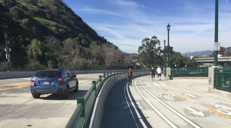
At Monday's opening ceremony, Mayor Eric Garcetti, Councilmember Gil Cedillo, LADOT General Manager Seleta Reynolds and others praised the new bridge's features. It is the first Los Angeles bridge to include a protected bikeway: a 2-way bike path, with parallel walkway. The bikeway extends the existing 8.3-mile L.A. River bike path an additional one-third of a mile. The bridge touches touches down on L.A. City's first two-lane roundabout.
Speakers emphasized that the new protected bike/walkway will benefit safety, because it separates bicyclists and pedestrians from car traffic.
Unfortunately, I know the project is not really about safety. It is about car capacity. The city tore out a historic landmark bridge, in order to widen and straighten so that more cars can go across faster. The old Riverside Drive bridge was essentially L-shaped; it consisted of two bridges: a sidehill bridge along the river and a span across the river. The L-shape and the overall scale acted to calm traffic somewhat. The new curved bridge is, like a freeway, designed for cars to move faster.
That slow-moving two-car-lane neighborhood-scale bridge was re-made into an over-sized freeway-scale four-car-lane-width bridge.
I fought this project for years, as a cyclist and river advocate. I describe the new bridge as "wider straighter faster deadlier." The traffic predictions (a flawed pro-car pseudo-science) did not warrant road widening. A single-lane roundabout would have been safer, more pedestrian-friendly, and sufficient for car traffic volumes. The city traffic engineers kept the roundabout idea, but unnecessarily inappropriately scaled it up to two lanes. The city bridge builders, faced with a three-part bridge worth triple the rehabilitation funding than ordinary bridges, refused to scale back the excesses and dangers of their planned bridge replacement project.
The city's early designs called for the bike path to go under the new bridge and cross the river on a separate bike-ped bridge just downstream from the new bridge. River and bicycle advocates were concerned that this would create an out-of-the-way gauntlet, a security risk, an area likely to be colonized by the homeless. With a fair amount of public pressure, and some leadership from then-Councilmember Ed Reyes (whom I worked for from 2002 to 2004), the city's engineers reluctantly agreed to the final design that placed the protected bikeway on the bridge.
The protracted struggle for an appropriately-scaled Riverside Drive Bridge was among the most frustrating of my activist career. Even with a pro-bike, pro-river-revitalization councilmember, the city's technical "experts" forced in auto-centric infrastructure, further degrading an already car-infested area. It is not just any average area. This location, the confluence of the L.A. River and the Arroyo Seco, is where L.A. started. It is described in the earliest written account of the Los Angeles area. Here is that description, taken from Blake Gumprecht's The Los Angeles River: Its Life, Death, and Possible Re-Birth:
[The 1768 Portola Expedition] entered “a very lush green valley,” [diarist Father Juan] Crespi wrote, where they found the [Los Angeles] river … It was a “good-sized, full flowing river,” about seven yards wide , he estimated, “with very good water, pure and fresh.” … Just upstream from the point where they first saw the river, the explorers noticed another stream that emptied into its channel, but its large bed was dry on that late summer day. This stream we now know as the Arroyo Seco. “The beds of both are very well-lined with large trees, sycamores, willows, cottonwoods, and very large live oaks,” Crespi wrote. … He noted the presence beside its channel of great thickets of brambles, abundant native grapevines, and wild roses in full bloom. Sage was plentiful near the river, and the calls of turtle doves, quail, and thrushes filled the air near the camp. It was “a very lush and pleasing spot, in every respect,” he wrote. “To (the) southward there is a great extent of soil, all very green, so that it can really be said to be a most beautiful garden.”
The discouraging struggle over the Riverside-Figueroa Bridge gave me the realization that too often the push for livability in Los Angeles takes years, and results in frustrating, inadequate, half-a-loaf compromises.
I lost this battle a decade ago. Later other folks pushed, and even filed a lawsuit to preserve the historic bridge. All of this faced stubborn intransigence on city engineers' behalf.
Visiting the bridge this week, I acknowledge that this project will help the city connect the L.A. River bike path to the Arroyo Seco and into downtown Los Angeles (more on that below). I see that river, bike, and walk efforts have gained momentum in the past decade and the city of Los Angeles is now in a somewhat better place regarding accommodating active transportation and respecting its river. Yet, I still have a bad taste in my mouth over my past frustrations with this crappy bridge.
Below is a photo tour of the new Riverside Drive Bridge. Note that this is one of at least four Riverside Drive bridges in the city, so it is often called the Riverside-Figueroa Bridge, as it is where Riverside Drive becomes North Figueroa Street.
The bridge is located near the intersection of the 5 and 110 Freeways.
The new bridge's protected bikeway extends the Glendale Narrows L.A. River bike path across the river to Cypress Park. From there, the expectation is that path will extend along the northeast side of the river, through Lincoln Heights, and into downtown Los Angeles. The path will extend further through downtown and connect with the South County L.A. River Bike Trail at Atlantic Avenue in the city of Vernon.
In theory, the connection into Lincoln Heights, and at least to Arroyo Seco, would be done by closing one or more (or all) lanes of Avenue 19. During bridge construction multiple lanes of Avenue 19 were closed.
Prior to construction, Avenue 19 had been striped for four lanes of traffic. This was reconfigured down to two lanes as part of the new bridge construction. Unfortunately, the lane reduction appears to be more about giving cars bigger, faster lanes (like the new bridge above it), with no new Avenue 19 space allotted for bicyclists or pedestrians yet.
The recently-approved Measure M sets aside $425 million to close all the gaps in the L.A. River bike path. Hopefully, soon, the new more safety-minded and bicycle-friendly city departments can work with communities and river and bike advocates to close some or all of Avenue 19, and extend the bike path and river greenway downstream.


