SB 79 Implementation in San Diego

(Over the next two weeks, we are partnering with BuildSD and Strongtowns Oceanside on a multi-part series on SB79 implementation in San Diego County. You can read this piece where it was first published on Build SD, or read all of Build SD’s analysis of SB 79 implementation here.
We’ll have more details on the future Streetsblog San Diego tomorrow or Wednesday. If you want to help us out before our launch, you can make a donation here. – DN)
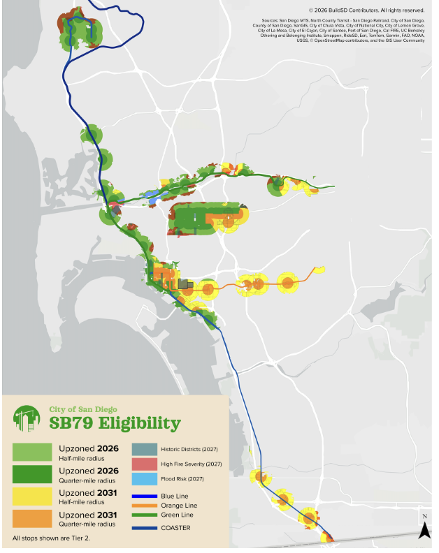
On May 7th, the San Diego City Council held a special meeting to discuss the City’s implementation of SB 79 (Wiener). While still vague on timing, changes during the meeting led to a specific plan for which upzoning-eligible areas would and would not be delayed, as well as time ranges for the delays. In the meeting, the Council also identified 48 additional stops that might be added to the City’s SB 79 plan if the San Diego Association of Governments (SANDAG) were to update its interpretation of the bill. Now, SANDAG has released their Draft SB 79 Transit-Oriented Development Map and has added many of these additional stops.
TLDR: The San Diego Planning Commission will determine what will happen to delayed areas in Spring 2027. In Summer 2027, if not earlier, the Council will adopt a plan to determine how to delay or exempt areas. Upzonings in non-delayed areas will go into effect on July 1st, 2026.
San Diego will most likely adopt guidelines for all delayed areas, except Low Resource Areas, following the Summer 2027[1] adoption of the Transit-Oriented Development (TOD) Alternative Plan. Low Resource Areas will be upzoned no later than 2032. Additionally:
- San Diego will use the State’s fire map, not the stricter local fire map as previously planned
- San Diego is planning to exempt areas in Very High Fire Severity zones if they are on a single-exit street or in a single-exit neighborhood
- Historic properties will be delayed until Summer 2027, but San Diego is not currently planning to exempt any historic properties
- Areas beyond a 1 mile walking distance from a TOD stop will be excluded
- Areas at risk of flooding with a 1 foot sea level rise will be delayed until Summer 2027
- San Diego is potentially allowing up to 52 additional bus stops to be eligible for SB 79, dependent on SANDAG’s interpretation of the bill’s text, bringing the total count of potential eligible stops up to 103
[1] The San Diego Planning Commission is to have the city’s TOD alternative map for delayed areas ready by Spring 2027, and City Council is to adopt it by Summer 2027. Many edits and exemptions will be made during this process, and there is no guarantee City Council approves this plan. All Summer 2027 timelines are based on this, but they can be delayed until 2032 at the latest.
San Diego’s implementation will likely be one of the most pro-housing implementations of SB 79 in the state, while also being one of the most legally sound interpretations of the bill. YIMBY Democrats of San Diego County, the Housing Defense Fund, and many other organizations, including BuildSD, were in support of this interpretation of the bill.
Very High Fire Severity Zones
Originally, the City of San Diego had used their own local fire risk map for SB 79 implementation. However, the bill requires localities to utilize the State of California’s fire risk map, and to only consider Very High Fire Severity Zones. This has led to a large reduction in area eligible for fire risk delay. Before this update, the area subject to fire risk delays was 30% of the total SB 79 area[2]. Now, the fire risk delay area is less than 5%.
[2] This figure excludes the newly added bus stops.
While some areas will still be exempted due to fire risk, San Diego is planning this for single-exit properties and neighborhoods only. This is consistent with changes made to the Bonus ADU program in 2025. However, the Bonus ADU variant of this policy relies on the City’s fire map, while the SB 79 implementation will depend on the State’s fire map.
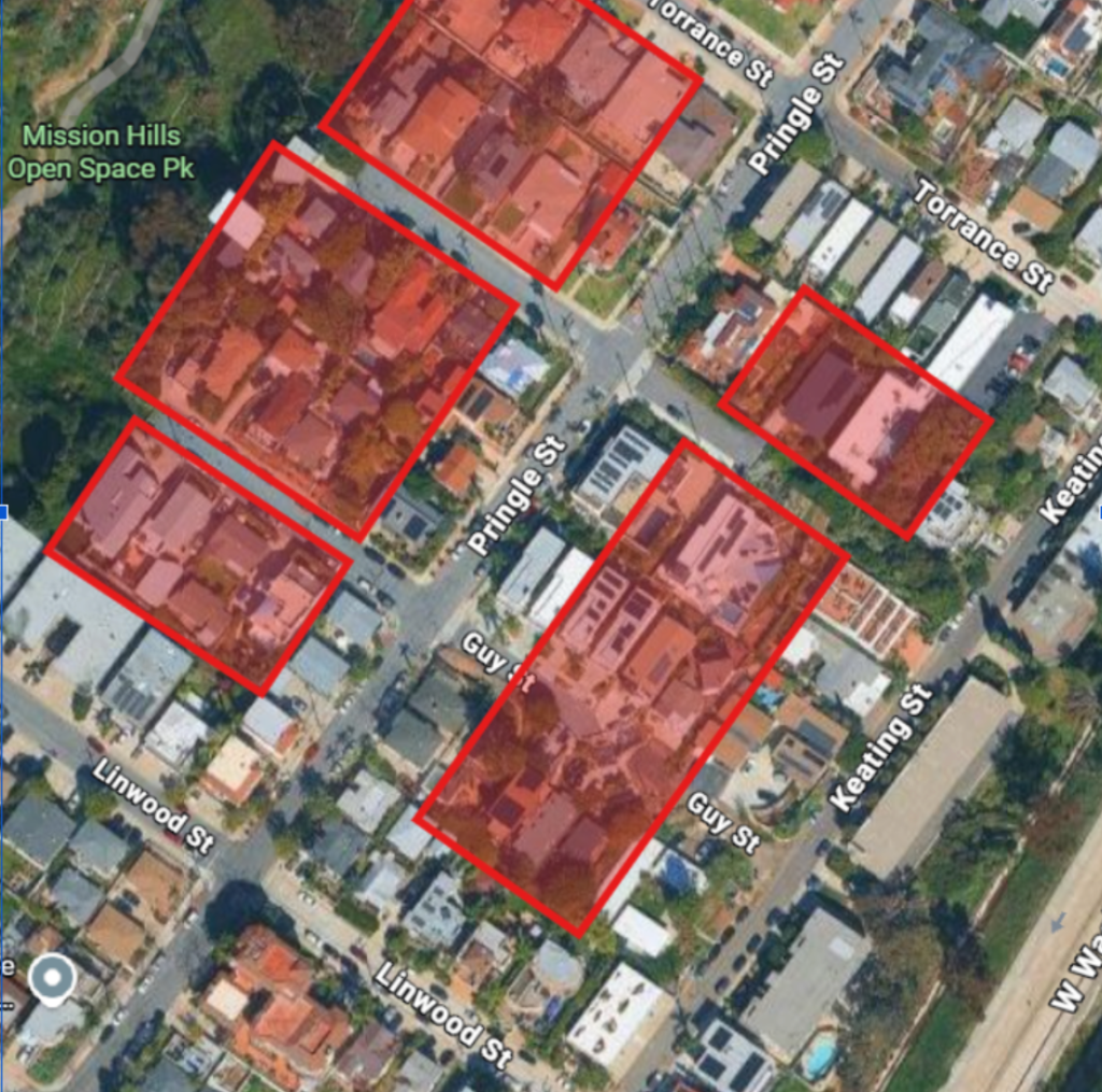
The areas affected by the Very High Fire Severity exemption are primarily in University City, as well as parts of Mission Valley, Old Town, Mid-City, and San Ysidro.
The City considers almost the entirety of Mission Valley, areas around the Orange Line, and much of the Blue Line in South San Diego as high fire risk, as well as portions of University City and Clairemont. This change means much of Mission Valley and areas along the Trolley’s North Line will be able to have SB 79 implemented starting in June 2026 instead of 2027, and will not be eligible for exemptions. While fire safety is an important and complicated topic, new buildings are much safer in fires than their older counterparts, and any buildings built in the City’s fire zone would still need to be built to City standards.
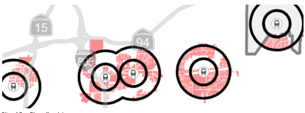
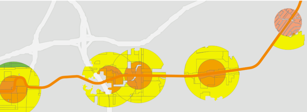
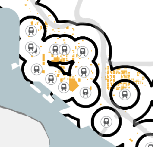
TOD Stops
The next major change concerns TOD stops – the stops identified by SB 79 as being eligible for upzoning. San Diego, at the direction of SANDAG, initially listed only 4 bus stops as TOD stops. Now, there are potentially 52 eligible bus stops. This has increased the zoned area by nearly 15% and has vastly increased the area that will be immediately upzoned in July, including in some of the City’s most walkable, bikeable, and transit-rich neighborhoods.
Per state vehicle code, a dedicated bus lane can still allow turning cars, bikes, and other permitted vehicles while still being considered an enforceable dedicated bus lane. These shared-use bus lanes are found not only in San Diego, but also in San Francisco, where bus / taxi lanes are a fixture in many areas. BuildSD contributing writer Sam B. went further and called the office of Senator Scott Weiner. Their office confirmed the YIMBY Democrats of San Diego interpretation that these lanes count under SB 79. Resolving this discrepancy led to the new bus stops being added to the City’s SB 79 implementation.

Some bus lanes and bus stops on El Cajon Blvd, University Ave, and Park Blvd have been added to the implementation. While some of these neighborhoods, areas like North Park and Hillcrest, have been recently upzoned by the city, others have not had their land use plans updated in decades.
In San Diego, all Trolley stations and some bus and rail stops are included as TOD stops. All stops within the City are Tier 2 under the bill, and all qualifying rail stops are shared with the Trolley. Per the bill, the radius is calculated from each station exit, so larger stations mean slightly more area is covered.
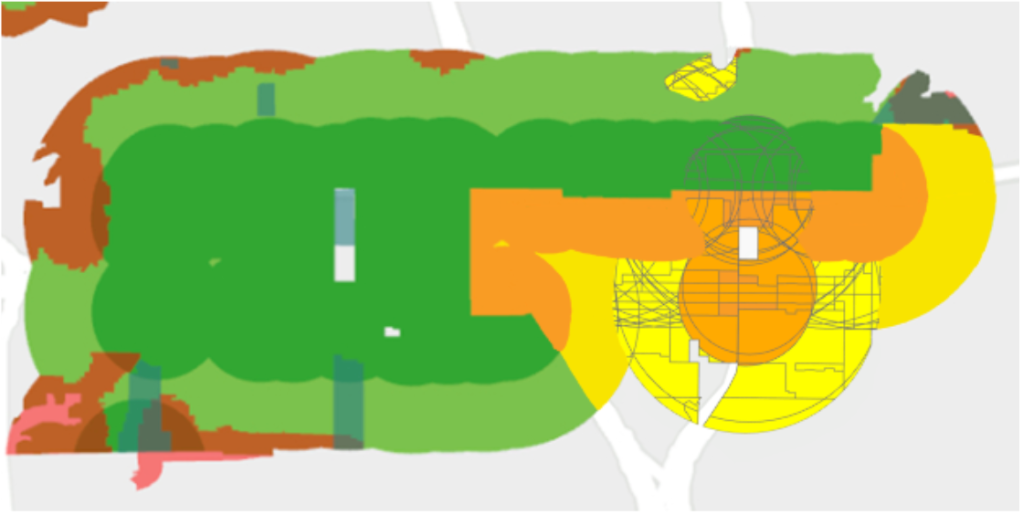
One-Mile Walkshed Exemption
SB 79 allows cities to exempt areas within the half-mile and quarter-mile radius of a TOD stop if they are further than a one mile walk from the stop. Most cities subject to SB 79 are using this exemption, as it prevents areas where walking to the station is not viable from being upzoned as transit-oriented.
Community Plan Updates
Areas that are currently receiving updated community plans will have their transit-oriented upzoning implemented as part of that plan, even if it is considered a delayed area. This would affect the Mid-City and Otay Mesa Nestor Plan updates, upzoning these areas in 2027 or 2028 instead of waiting until – in some cases – 2032.
Historic Districts
While SB 79 does allow for cities to exempt historic buildings and shift density in some places, the City of San Diego decided to allow these historic areas to be upzoned by Summer 2027. While there is still potential for buildings to be exempted, San Diego will likely not do so. San Diego has already allowed development in many historic areas. However, due to the cost of building on a historic site, it is not especially common outside Downtown or parts of Mid-City and Uptown.
The areas primarily affected by this are Downtown and Sherman Heights. While places like Old Town are historic districts, there are very few locally designated historic resources there. The bulk of the historical sites are either part of Old Town State Historic Park or protected at the federal level on the National Register of Historic Places.
Flood Risk Areas
If a site is at risk of flooding by at least a foot of sea level rise, it is eligible for exemption or delay from SB 79 under a TOD Alternative Plan. The City of San Diego has said that areas at risk of flooding from sea level rise will be upzoned in Summer 2027. Within the city limits, this provision only affects Mission Valley, as the area is at sea level.

Low Resource Areas
Per SB 79, Low Resource Areas can only be delayed fully if the city already has at least half of the SB 79 zoned capacity. San Diego has exceeded this, as we have zoned for 60% of what SB 79 allows, not including areas surrounding the newly added bus stops. Low Resource Areas take up 24% of the SB 79 area in San Diego, so it is the largest remaining delay. During the meeting, Councilmember Vivian Moreno, whose district is mostly within Low Resource Areas, asked for this delay to be until 2027 as well. However, she was overruled, and the extent of this delay will likely come down to a political fight in Summer 2027.
Additional SANDAG stops
On June 18th, SANDAG released the Draft SB 79 Transit-Oriented Development Map. This map adds additional stops to the map in downtown and at UC San Diego, beyond the TOD stops identified by the City. This change has the potential to set a precedent that could include additional stops.
The most important bus stop addition which is not displayed on the BuildSD SB 79 map is UC San Diego’s Gilman Transit Center. This extends the SB 79 TOD zone further west. While much of the area is dominated by the UC San Diego campus, some chunks of La Jolla are also included. A portion of this area is a Very High Fire Severity Zone so it remains to be seen how much is eligible for SB 79.
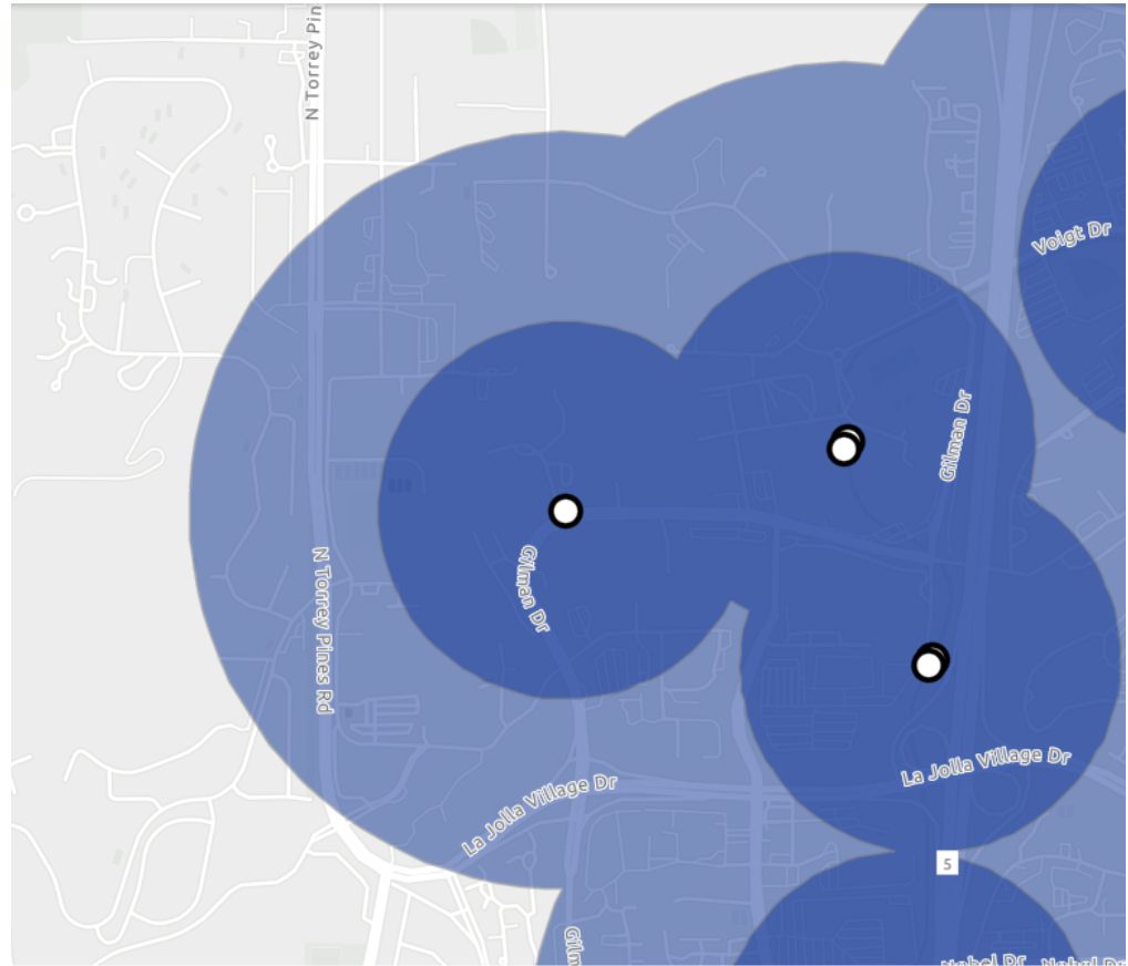
SANDAG’s map also notably omits some bus stops on El Cajon Blvd, University Ave, and Park Blvd. The most obvious is a large gap caused by the Rapid 215 stop at 35th Street being omitted. It is unclear why this choice was made as it is identical to many included stops. As discussed in our Solana Beach SB 79 breakdown, the map has also failed to account for shared stops on the COASTER and the Pacific Surfliner, although this does not affect stops within the San Diego city limits.
While a few Councilmembers during the meeting did point out how the bus lanes on El Cajon Blvd were dedicated bus lanes, Stephen Whitburn and Vivian Moreno explicitly went to bat for these stops, voting against the resolution to pass San Diego’s SB 79 interpretation as presented, as these corridors were not included. This was also the point at which the High Fire Risk areas and sea level rise area changes were made.
The change that Whitburn and Moreno pushed for was, of course, a difficult compromise. However, we expect it to keep San Diego compliant with SB 79 and allow more TOD projects in some of the city’s most walkable, bikeable, and transit-friendly areas.
Further Reading
February 13 Memo: Senate Bill 79 Overview and Compliance Options
Thursday May 7 Special Council Meeting Agenda
Thursday May 7 Special Council Meeting Results

Streetsblog has migrated to a new comment system. New commenters can register directly in the comments section of any article. Returning commenters: your previous comments and display name have been preserved, but you'll need to reclaim your account by clicking "Forgot your password?" on the sign-in form, entering your email, and following the verification link to set a new password — this is required because passwords could not be carried over during the migration. For questions, contact tips@streetsblog.org.