Four Years Late, North Spring Street Bike Lanes Installed
They are four years late. They are not perfect. But, rejoice, the city of L.A. has finally installed bike lanes on the renovated North Spring Street bridge.
The bridge – technically, the North Spring Street Viaduct – spans the Los Angeles River just northeast of downtown, connecting the neighborhoods of Lincoln Heights and Chinatown.
The new bike lanes had been approved to be included in the city’s bridge widening project, but were blocked by the area’s strongly anti-bike City Councilmember Gil Cedillo. Earlier this year, the incumbent Cedillo lost his bid for re-election; starting in December, Council District 1 will be represented by progressive challenger Eunisses Hernandez.
Below is the timeline on the project – click on links for greater detail:
- 2006: The city’s Bureau of Engineering (BOE) proposed tearing down historic 1927 North Spring Street Viaduct to widen its deck from about 43 feet to about 96 feet. Preservationists and others fought the project. Ultimately the city scaled back its plans, reluctantly agreeing to instead widen to only 68 feet, which allowed the project to extend the existing structure with no tear down.
- 2011: L.A. City Council approved bike lanes in the project’s final environmental studies.
- 2013: Cedillo replaced termed-out bike-friendly Ed Reyes as councilmember for CD1.
- 2018: The renovated N. Spring Street Bridge reopened without bike lanes. A BOE representative stated that the bike lanes would be included in the second phase of the project, and were anticipated to be installed in “approximately six months.”
- 2021: By April 2021, BOE had completed second phase work (tearing down a hundred year old building to extend Wilhardt Street), but still had not added a bike lane. Advocates began legal proceedings to push the city to adhere to state environmental law by adding the approved lanes. City emails, dated October 2020, stated that bike lanes could be installed “next week.”
- January 2022: SBLA shared public records confirming that Cedillo had actively blocked the already-designed bikeway.
- Early 2022: BOE closed out the N. Spring Street Bridge renovation project, essentially declaring the work complete. A BOE spokesperson stated that the city “intend[ed]” to install lanes after June.
- May 2022: L.A. Times endorsed “visionary and pragmatic organizer” Hernandez for many reasons. The Times also cited several Cedillo shortcomings, including linking to SBLA coverage of Cedillo blocking the N. Spring Street bikeway.
- June 7, 2022: Voters elected Hernandez outright in the statewide primary election. Though Cedillo led narrowly on election night, the final count showed Hernandez received 54 percent of votes cast.
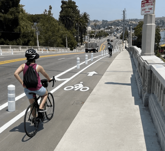
- July 2022: Late last week, L.A. installed protected bike lanes on N. Spring Street Viaduct.
The new bike lanes include plastic bollard protection.
The bridge bike lanes are part of a planned 1.8-mile bikeway connection (mostly on-street bike lanes) all the way from the Chinatown L Line Station to the L.A. River walk/bike path terminus at Avenue 19 and San Fernando Road in Cypress Park.
As part of installing bike lanes on the bridge, the city also striped a missing one-block stretch of North Broadway, immediately north of the bridge.
There are unfortunately still two remaining gaps in that planned facility:
- LADOT announced it would, in Fiscal Year 2019-20, add bike lanes on Avenue 19. BOE had widened an Arroyo Seco bridge there, but omitted adding new bike lanes as part of that project. SBLA has been unable to confirm why those lanes were delayed, but it is likely that they, too, were blocked by Cedillo.
- There is also a ~200-foot gap between the new Spring Street lanes and the bike path fronting L.A. State Historic Park. As part of the second phase of the N. Spring Street project, the city tore out a building to extend Wilhardt Street, which now connects Spring to the park – ostensibly “to improve bicycle and pedestrian circulation and safety.” But the city only added shared-lane markings (called sharrows, which, for most settings, are not safer than an unmarked street), despite the fact that Wilhardt is a 44-foot wide two-lane street with no parking. And, perhaps to make it clear that city engineers have no sense for accommodating safe bicycling, the sharrows only go one way. The city somehow concluded cyclists will go from Spring Street to the park, but not from the park to Spring. Go figure.
In addition to the ridiculous one-way sharrow on Wilhardt, the city added a couple more sharrows where its transportation professionals failed to find sufficient space to extend the Spring Street lanes. There is one northbound sharrow on N. Spring, just south of the bridge. And there is one sharrow northbound, where the city added a right-turn-only lane onto Avenue 18, just north of the bridge.

Streetsblog has migrated to a new comment system. New commenters can register directly in the comments section of any article. Returning commenters: your previous comments and display name have been preserved, but you'll need to reclaim your account by clicking "Forgot your password?" on the sign-in form, entering your email, and following the verification link to set a new password — this is required because passwords could not be carried over during the migration. For questions, contact tips@streetsblog.org.