Eyes on the Street: Alameda’s New Dining Lanes
Note: GJEL Accident Attorneys regularly sponsors coverage on Streetsblog San Francisco and Streetsblog California. Unless noted in the story, GJEL Accident Attorneys is not consulted for the content or editorial direction of the sponsored content.
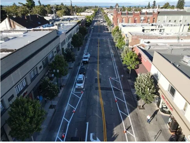
Late last week the city of Alameda did a quick reconfiguration of Park Street, converting a stretch of its former six-lane configuration (two lanes in each direction for car traffic, plus two additional lanes for parking) into a street designed to prioritize more than cars.
It now has only one lane in each direction for motor-vehicles, plus parking, plus a lane for outdoor dining. As seen in the lead image, the new treatment runs from Encinal to Santa Clara, with more planned between Santa Clara and Lincoln.
From Alameda’s web page about the “Commercial Streets Program,” a response to the need for social distancing in the time of COVID:
This program streamlines the permit approval process for expanding dining and retail into new parklets (using parking spaces) and the sidewalks. The program will also repurpose the roadway along core parts of Park and Webster Streets to greatly increase the area available for outdoor dining and retail. City staff worked closely with the Downtown Area Business Association (DABA) and the West Alameda Business Association (WABA) to develop this new program, which will support the health of our businesses and the community.
In other words, Alameda has built parking protected restaurant dining lanes.
Unfortunately, the rising COVID case load in Alameda County and the subsequent backpedaling on allowing outdoor dining has put a damper on the plans–for now. But advocates for safe and livable streets see the new street configuration as a positive development regardless.
“My new mantra. Keep the lanes for bikes and walking. Keep the lanes for bikes and walking. Keep the lanes for bikes and walking,” wrote Lucy Gigli of Bike Walk Alameda, in a post on social media about the new configuration.
Brian McGuire of the city of Alameda clarified in a social media post that this is “not a bike lane,” but rather “extra space for outdoor dining/retail/social distancing.” However, he admits that it “Looks very bike lane-ish though since the tables and chairs and parklets aren’t there yet.”
“Both the business district and the city are closely monitoring this project, with the idea that some form of it might continue after things are ‘back to normal,’ if it’s a success,” wrote Rochelle Wheeler, Senior Transportation Coordinator for the city of Alameda, in an email to Streetsblog. As it turns out, the city is presenting plans for bike lanes on Park later this week. “Both Park Street options include adding bicycling facilities to the street, and one includes a floating bus stop.”
As mentioned, a similar dining-lane project is planned for Webster, from Lincoln to Taylor. And the Park Street project might be extended to San Jose Avenue.
Streetsblog took a tour of the area this morning by bike, and it’s certainly easier and safer to ride on the stretch with this new treatment. There’s still too many construction signs in the “dining lane” to try biking in it. But it’s easy to imagine that this new basic configuration is here to stay. And as McGuire wrote in his tweet, it’s a testament to how fast cities can bring changes to our streets.
A few more photos below:

Streetsblog has migrated to a new comment system. New commenters can register directly in the comments section of any article. Returning commenters: your previous comments and display name have been preserved, but you'll need to reclaim your account by clicking "Forgot your password?" on the sign-in form, entering your email, and following the verification link to set a new password — this is required because passwords could not be carried over during the migration. For questions, contact tips@streetsblog.org.