Urban planner Mike Lydon, whose firm, Street Plans, is based in Brooklyn, was shocked by the way the de Blasio administration conducted its recent — and failed — open streets pilot, which ended up being scrubbed after 11 days because the mayor required it to have a substantial deployment of police employees. But creating open streets doesn't have to be so difficult, as many other cities are proving. Here's Lydon's guide:
The threat of coronavirus transmission has inspired cities large and small to harness their streets to deliver quick, low-cost physical distancing interventions that make essential travel and physical exercise less risky. I’ve been documenting the emerging trend in an open Google Sheet for several weeks, which now includes 60+ cities across the globe.
In these places, one or more of the following six tactics are being deployed by local leaders to give people more space. They include:
- Opening streets (full): From Duluth to Des Moines to Denver, roads within or adjacent to parks and/or waterfronts are common targets because they are magnets for active recreation. They are also easy to open because they do not serve a primary transportation function, which conversely limits their utility for essential workers.
- Opening streets (partial): Repurposing travel or parking lanes at transportation pinch points or along key travel corridors provides more space on otherwise cramped sidewalks where maintaining six feet of space is almost impossible. Cities such as Austin, Brookline, and Montreal are using this tactic.
- Unsanctioned, resident-led block openings: Some residents are taking matters into their own hands, opening their blocks for pedestrian use and local vehicular travel only. Some of these, like Portland’s Sam Balto’s daily phys-ed classes, are “time-of-day” openings.
- Shared streets: With historically low traffic volumes, cities like Oakland and Burlington are proactively reducing traffic further by filtering out thru traffic in favor of local and emergency access. This leaves more space for people on streets otherwise dominated by cars in primarily residential settings.
- Temporary bikeways: Filling network gaps, adding physical protection, or simply widening bike lanes are three ways cities like New York, Berlin, and Budapest are accommodating the surge in “essential cycling.”
- Changing pedestrian signals: Cities are putting pedestrian signals on recall, meaning the walk signal appears automatically, eliminating the need to press those germ-magnet “beg buttons.”
Of these six tactics, five require physically altering the right-of-way. So, how are cities doing it? Here’s a quick primer covering barriers (types, placement), signs, deployment, and monitoring.
Barriers
Type
When it comes to barriers, don’t overthink it. This is not a time to be overly concerned with maintenance or aesthetics or take on time-intensive activities, like filling barricades with sand or water, transporting cement blocks, or moving and filling planters. Instead you’ll want barriers that are easily transportable but substantial enough to be legible by all street users. Any form of orange/reflective traffic barricade is a good option and may provide scaffolding for associated signage.
Other options include anything stackable or foldable: traffic barrels, cones, whatever is on hand at your city’s Public Works warehouse and commonly deployed by the city for construction detours or special events. Trust that citizens have internalized these elements as signifiers of slow travel and will adjust behavior accordingly.
If your city is short on supplies, consider renting from a local contractor or supplier, as most could really use the income at this time.
Placement
Placement of barricades will vary depending on the intervention but should follow normal standards. For example, cones or traffic barrels should be placed a maximum of 15 feet apart along the edge of a bikeway to deter vehicular entry.
Perhaps less obvious is how to effectively filter local streets. Some cities are using barricades as diverters, blocking access to one direction of thru traffic, while those with wider streets are placing them on the center line, forcing motorists to carefully navigate around them, if at all.
Another option is to align cones or barricades diagonally across a four-legged intersection, forcing right or left turns for vehicles every few blocks. This allows people walking, cycling, jogging etc. through movement but keeps vehicular traffic to a minimum. Spacing can ensure emergency vehicle access or the use of mountable cones can simply be driven over in an emergency.
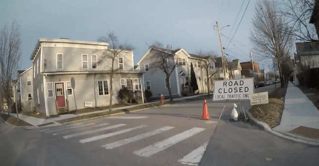
For full closures, barricades need to be spaced so as to limit incursion from motor vehicles, save for emergency responders, and should ideally be paired with advanced warning signs. Speaking of which..
Signs
Signing techniques for temporary street interventions vary. Cities like Burlington, Vt. are utilizing everything from bespoke coroplast signs, to formal retroreflective MUTCD signs, to variable digital message boards. All of the above can be used in various ways to communicate new patterns to the traveling public. Given that the city re-tooled 25% of their city streets to support physical distancing, this “kitchen-sink” approach was probably crucial to achieving scale.
Temporary traffic control signs that are often used in advance of and within construction zones are having a moment. Such signs are often lightweight and mounted on collapsible stands, making them easy to transport and adjustable in the field. If such signs are not available, work with a local printer to create MUTCD-compliant coroplast signs that can be hung with zip ties or affixed to barricades.
Beyond sign type one should consider scale: Motorists can’t read small coroplast signs placed along the sidewalk planting strip, just as active travelers don’t require over-sized flashing message boards to encourage them to use an open street. If you are promoting physical distancing or opening streets, make sure all users receive the message at an appropriate scale.
Finally, signs are important but not nearly as important as physically limiting thru traffic. When traffic volumes drop significantly human nature will take over - even without temporary physical distancing measures in place, people across the globe are jogging or walking in streets, an activity that weeks ago would have been a deadly endeavor. If this is happening in your city, it’s likely a sign (pun intended) that more distancing measures are needed, not less.
Deployment
Deployment is primarily being led city public works crews. Of course staff availability is challenging and varies from city to city, week-to-week, and even day-to-day. For those employees who are available, know that undertaking these interventions are a muscle that can be flexed with relative ease, as such measures are similar to installing temporary roadway construction or large special events.
Monitoring
Most cities do not have the capacity to check these interventions daily, nor is it an appropriate use of police resources. Instead, leaders should strongly consider leveraging crossing guards, block associations, BIDs or other local non-profits/groups to monitor and manage small adjustments in the field. Is a barricade knocked over? Pick it up. Was a cone moved off the street? Put it back. These basic stewardship activities are not technical tasks and can be managed by citizens, effectively helping city leaders focus limited resources where they are needed most.
If you’re a resident benefiting from increased space please take the time before you engage in essential travel or daily exercise to thank your political leaders and city staff. They are proactively and pragmatically using low-cost, proven measures to create more public space that supports your physical and mental health. With luck, they’ll continue to provide such spaces long after the COVID-19 pandemic recedes.
