Phoenix Will Continue to Let People Die in the Streets
Phoenix has one of the nation’s highest pedestrian death rates, but its City Council is in no hurry to address it.
On Tuesday night, the city’s legislative body failed, by a 4-4 vote, to move forward with a Vision Zero plan that would address the accelerating safety problem in the so-called Valley of the Sun.
Fast-growing Phoenix is a nightmare for pedestrians, thanks to its wide, high-speed streets with few accommodations for those on foot. The city of 1.6 million had 92 pedestrian deaths in 2017 — a staggering 125 percent increase over the last decade. (By comparison, New York City, with more than 8.5 million people, had just 107 pedestrian deaths that year.) According to city staff [PDF], 642 pedestrians were injured in Phoenix that year.
But rather than address the problem, the City Council caved to conspiratorial line of attack from bombastic Council Member Sal DiCiccio, who said that the Vision Zero plan would lead to lower speed limits across the city. He also argued that slower driving would (somehow) raise taxes. (Phoenix’s Vision Zero plan did not call for lowering speed limits across the city.) DiCissio also, without any evidence, said the whole problem could be blamed on potholes.
But that’s not what the data shows. The state likes to blame drunk pedestrians for its nation-leading pedestrian fatality rate. But the Arizona Republic found the deaths are happening in clusters. An investigation found a dozen locations around Phoenix where 10 serious crashes or five deaths had occurred within 300 feet of each other. Together these locations accounted for 10 percent of the total number of pedestrian deaths.
These places had a few things in common: They featured wide high-speed roads, almost always with at least five lanes and 40 mph speed limits. And they often had large gaps between signalized intersections. Most had not been substantively redesigned in decades, the Republic found.
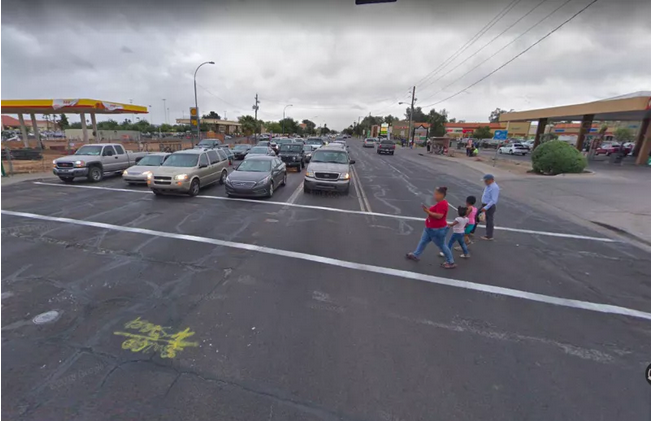
According to City Hall, 78 percent of pedestrian deaths occur on “arterial roads” like the one pictured above. And only about a third occur within 500 feet of a signalized crossing. In about a third of the cases, as well, the driver does not stop.
So far, in Phoenix efforts to improve pedestrian safety have been pretty limited, and have mostly involved installing “Hawk” signals, mid-block crossing signals. But the Vision Zero plan called for more aggressive fixes, like narrowing travel lanes and adjusting the speed limits on certain streets.
David King, an urban planning professor at Arizona State University, said the objection to speed limit changes was disappointing, and a symptom of growing political polarization, even in local politics. It’s not potholes, King told Streetsblog, it’s bad design, with too few safe crossings and streets that encourage speeding.
“Asking someone to travel to the closest crosswalk is silly — for someone on foot, a detour of up to a mile just to cross a street in unrealistic,” he said. “So people risk it, and unfortunately the risk is a chance of death.”
Three other council members joined DiSiccio in opposing the legislation, two of them offering procedural objections. DiCissio has also been a leader of an effort to take tax funds from transit in favor of road projects. He is affiliated with Americans for Prosperity, the billionaire industrialist Koch Brothers’ dark money political operative.

Streetsblog has migrated to a new comment system. New commenters can register directly in the comments section of any article. Returning commenters: your previous comments and display name have been preserved, but you'll need to reclaim your account by clicking "Forgot your password?" on the sign-in form, entering your email, and following the verification link to set a new password — this is required because passwords could not be carried over during the migration. For questions, contact tips@streetsblog.org.