New Tool Makes it Easy to Estimate Added Travel from New Highway Lanes
Note: GJEL Accident Attorneys regularly sponsors coverage on Streetsblog San Francisco and Streetsblog California. Unless noted in the story, GJEL Accident Attorneys is not consulted for the content or editorial direction of the sponsored content.
A new tool is available from the National Center for Sustainable Transportation to help estimate how much vehicle travel a freeway or highway expansion will produce.
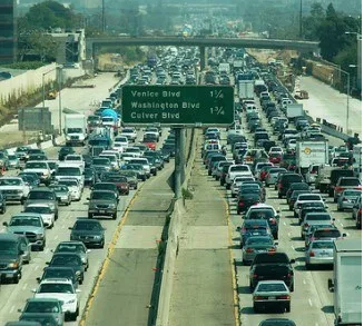
This tool is important now for a number of reasons. For years, California planners have responded to congestion by making highways wider so they can carry more cars. The result has been, not so surprisingly, more cars on those roads. Transportation planners argue that most new travel is pent-up demand that would happen anyway, but research has long shown that building more capacity leads to more driving.
Also, California environmental rules are shifting the emphasis of impacts that need study from congestion–vehicle delay–to the amount of travel (vehicle miles traveled, or VMT) a project produces. State agencies are only slowly coming to terms with the fact that VMT must be reduced if the state is to meet its climate goals–and it can’t do so as long as it builds highway lane miles that induce more travel.
The calculator is simple to use. Plug in the type of highway, how many lanes miles the project would add, and where it is in California, and out comes an estimate of how much new travel there would be about five to ten years after installation. It is based on data from several studies that measured the change in travel on hundreds of general-purpose and carpool lane additions in California. Those underlying studies have shown that capacity expansion tends to lead to a net increase in travel over time.
“This is a tool, not an oracle,” said Jamey Volker, a UC Davis researcher who is one of the tool’s authors. “But it helps bring to light something that is not really considered in the open: it is often not clear how estimates of increased travel are calculated, even in environmental documents.” This tool aims to make that task both easier and more consistent across the planning process.
The estimate accounts for shifts of travel from other roads onto upgraded facilities. “Sometimes if you open up a new lane, it will divert travel from other existing roadways,” said Volker. “But the studies show that over the long term, a facility adds new vehicle miles traveled without an appreciable reduction in travel on the rest of the network.”
Another reason the tool is timely is because of an idea has been popping up in planning documents lately. Highway planners have been claiming that additional capacity decreases emissions because it decreases “congested VMT.” The claim is made, for example, in the planning documents submitted in support of the Capital Southeast Connector (a new highway on the east side of Sacramento county), and in an argument floated by Senator Moorlach in support of his bid to widen Highways 5 and 99.
It is a specious notion.
Joe Cortright, in his City Commentary blog, spends some time breaking down the problems with similar arguments used by planners in Oregon who want to expand Highway 5 there. It’s hard for transportation planners to accept that what they’ve been doing for years hasn’t been working–that making freeways wider only brings, at most, temporary relief from congestion–despite the evidence of, say, the recent I-405 widening in L.A.
In addition, even that temporary congestion reduction brings other problems. “We have to be aware of the traffic impact at either ends of the ‘de-congested’ roadway,” said Volker. “Even if a capacity addition reduces congestion on the expanded segment, it will often increase VMT. As a result, congestion could worsen at either end of the expanded segment, where the existing unexpanded roadways must handle additional VMT.”
It’s also important to note that the tool applies to HOV, or carpool, lanes as well as regular use lanes. As the L.A. Times put it, “Adding carpool lanes has become the main tool for increasing road capacity to keep up with growing population and demand.” And it comes with a price: research shows that carpool lanes create more traffic, rather than lessening it.
Susan Handy, a professor at UC Davis who contributed to this research, told Streetsblog, “Logically, an HOV lane could be expected to have a different effect on induced travel. But an HOV lane is also a regular lane for much of the day, and it can be congested even when it’s not operating as an HOV lane.”
Even if you assume that adding carpool lanes did not induce as much travel as regular lanes, said Handy, “it wouldn’t mean congestion on already existing lanes would decrease. And while the HOV lanes themselves might be less congested, they would still increase VMT.”
The VMT tool is limited to particular highway types in the 37 “urbanized counties” in California. These are marked in blue, brown, and red here as well as on the map below.

It also should not be used to estimate new travel on HOT or “High-Occupancy Toll” lanes, where drivers can pay a toll or drive free if they are carpooling. This is because these roads have not yet been studied to see what their effect on induced travel is.
Also, Volker cautioned, “to be conservative, I would be cautious about applying the calculator to lane additions outside the Caltrans system.”
However, it should be very useful to Caltrans, which is beginning to produce internal guidance on estimating greenhouse gas emissions from transportation projects. That can’t be done without accounting for the amount of new travel they produce, which can now be done pretty easily.

Streetsblog has migrated to a new comment system. New commenters can register directly in the comments section of any article. Returning commenters: your previous comments and display name have been preserved, but you'll need to reclaim your account by clicking "Forgot your password?" on the sign-in form, entering your email, and following the verification link to set a new password — this is required because passwords could not be carried over during the migration. For questions, contact tips@streetsblog.org.