
Note: GJEL Accident Attorneys regularly sponsors coverage on Streetsblog San Francisco and Streetsblog California. Unless noted in the story, GJEL Accident Attorneys is not consulted for the content or editorial direction of the sponsored content.
San Joaquin Regional Transit District (RTD) launched a new service to make riding its system easier for people who are visually impaired and blind. The new “Talk to Me” audio and tactile maps of RTD stations are available now for people who need them, as well as for advocates and specialists working with visually impaired clients on how to get from point A to point B.
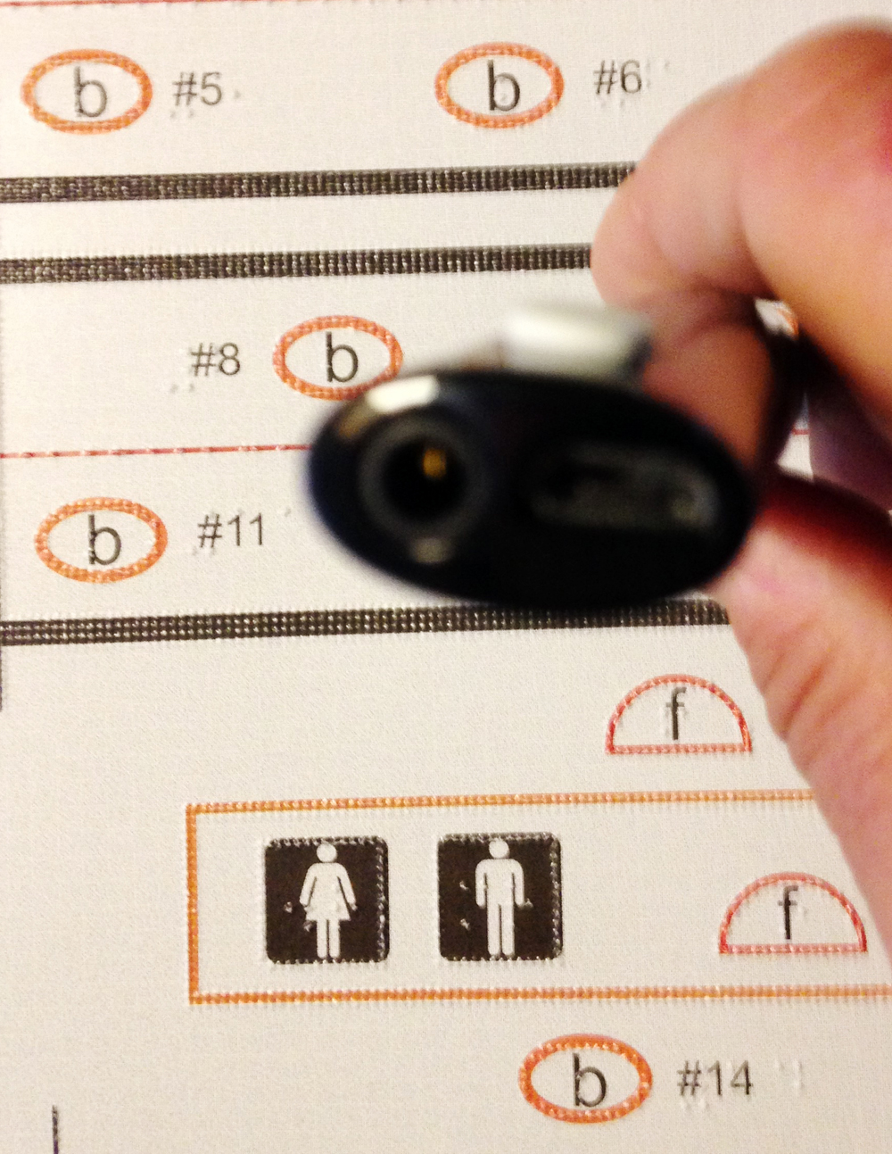
The tactile RTD maps are spiral-bound in a large book. Each page has an overview of a transit station, with descriptions of the station and instructions on where to board the bus and where the restrooms and ticket counters are located. It also points out any architectural barriers. The maps are currently available to borrow at four RTD transit stations: Downtown Stockton, Manteca, Lodi, and Tracy.
The maps were created by the Media and Accessible Design Lab team at Lighthouse, a San Francisco-based nonprofit. They have an uncluttered design, and are printed in high contrast color. They include embossed lines that people can run their fingers along, and have labels, key, and instructions in braille.
The map is paired with a Livescribe pen that “talks” to the user by giving audio information when it is tapped on different areas of the map. It works by responding to a microdot pattern printed on the map, using digital data capture technology developed by Anoto. The maps are simple enough for a sighted person to use, and provide a wealth of information to visually impaired and blind people.
Joni Bauer, an orientation and mobility specialist at the Stockton-based Community Center for the Blind and Visually Impaired, works with clients who range from people blind since birth to ones gradually losing their sight. She said that not all of them read braille, and the “talking” feature of the map is useful for people learning to navigate the transit system.
“It’s a great teaching tool,” Bauer said.
Nastassja Green, 26, rides RTD’s Hopper, a smaller bus that frequently deviates from its usual fixed route to drop people off closer to their desired destinations. She said RTD’s services are very useful to blind riders like herself, and the bus drivers she has encountered are helpful, but in the end “it’s still about orientation.”
“The maps can pinpoint certain things,” Green said.
Green has been blind since birth. She helped Bauer with the project by giving feedback on drafts of the tactile maps. She said she wishes they were more widely available, and for more than just transit—she would use them to navigate airports, or her neighborhood, or to find a good local place to eat.
Will Butler, communications director for Lighthouse for the Blind, says that one of the big problems faced by people with visual impairment or blindness is missing out on an overview of any given location. The embossed lines on the maps are an attempt to help create that overview.
“We (sighted) people really take for granted being able to glance at a map and know where we are,” he said.
LightHouse’s tactile and audio maps are already used by BART and the Muni system in the Bay Area, but San Joaquin RTD is the first transit agency in the Central Valley to take advantage of this resource. The organization also creates tactile maps for state parks and museums, and is working on software that will allow anybody to print a tactile map at home, with the right equipment.
“Everything that we do for the blind community comes back to mobility,” said Butler. Because most wayfinding systems are designed visually, he said, Lighthouse spends “a lot of time making mobility more adaptive.”
There are other high-tech resources that help visually impaired and blind people navigate their surroundings, such as BlindSquare, a GPS app, and Be My Eyes, an app that allows users to access visual assistance. But Butler points out that there is a lot of information to be learned through touch.
“Tactile literacy in general, across the board, is still a pretty unexplored realm,” he said.
Like all public transit agencies, RTD has to abide by the American with Disabilities Act by removing barriers to access for persons who are visually impaired and blind. The agency is required to provide a menu of resources such as paratransit, kneeling buses, braille signage, and audio assistance at fare dispensing machines.
Bauer also serves on RTD’s board of directors, and she brought the tactile map idea to RTD after meeting LightHouse for the Blind staff at a conference and exploring the maps they created for Muni and BART. She thought her organization’s approximately 200 clients, many of whom rely on public transit as their main source of transportation, would benefit from having access to them.
“And RTD just ran with it,” she said.
Terry Williams, public information officer with RTD, said the project cost $15,000, and required a lot of collaboration between agencies to make sure the maps are easy to use and the information on them is correct. Starting in January 2018, RTD will be changing some of its routes and stops, and will add a new station, but all the agency needs to do is call LightHouse and have them produce a new map page.
“It’s an evolving document and will likely become more useful as changes to the system occur,” Williams said.