How Highways Squeezed Taxable Land Out of Cities
When transportation planners gouged interstate highways through urban areas in the 20th century, they damaged some cities irreparably. One under-appreciated effect was the removal of central city land from the tax rolls.
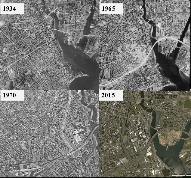
Thanks to the work of Kristin Floberg, an engineering master’s student at UConn, we can see just how much was lost in Bridgeport, Connecticut [PDF]. Floberg used historical fire insurance maps to inventory every building in downtown Bridgeport before cars came on the scene in 1913. She then compared the land uses to maps of 2013.
Bridgeport, like many cities in Connecticut, is fiscally distressed. The city attempted to declare municipal bankruptcy in 1991, an effort that was blocked by a federal judge.
In retrospect, the decision to ram I-95 and Route 8 right through downtown Bridgeport must be a factor in those troubles, when you look at the enormous amount of taxable land value the downtown area lost to highway infrastructure. Check out this chart based on data Floberg’s research, which was overseen by professor Norm Garrick:
So car-centric roads and highways consumed 21 percent of the total land area in downtown, doubling the amount of real estate taken up by road infrastructure.
Floberg also looked at how land uses shifted among structures that remain. There were dramatic changes that further reduced the taxable value of land downtown:
You can see in these before and after 3D renderings how dramatically the form of the city shifted. Green buildings are residential, blue are commercial, purple are industrial, and orange are municipal or tax-free structures.
Of course, aside from the budgetary implications, all of these changes — the added asphalt, the loss of buildings — made downtown much less walkable. Floberg quantifies that as well.
Using the downtown Bridgeport Metro-North train station as the reference point, she cataloged the number of buildings you could walk to in 1913 versus 2013.
In short, the number of commercial buildings within a short walk of the train station has fallen nearly 80 percent, the number of residential buildings has fallen 94 percent, while the number of tax exempt buildings has increased 250 percent.
“I think the big thing we took away from it was how much more diversity there was in 1913,” Floberg told Streetsblog. “Now in downtown Bridgeport there are mostly just municipal functions and commercial, and by commercial mostly large office buildings.”
“In 1913, there were so many different types of uses, little mom and pop shops and little factories. It brings so many different people to the city for different purposes.”

Streetsblog has migrated to a new comment system. New commenters can register directly in the comments section of any article. Returning commenters: your previous comments and display name have been preserved, but you'll need to reclaim your account by clicking "Forgot your password?" on the sign-in form, entering your email, and following the verification link to set a new password — this is required because passwords could not be carried over during the migration. For questions, contact tips@streetsblog.org.