L.A. Debuts New Interactive Vision Zero Map
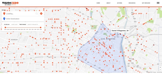
The city of Los Angeles has a new interactive Vision Zero map. The map shows the locations of recent traffic fatalities, identifying them by age, gender, and whether those killed were traveling by foot, bike, or car.
In case readers are not already familiar with Vision Zero, it is the city’s adopted policy to reduce traffic deaths to zero. The policy was first adopted as part of the city’s Mobility Plan 2035 and strengthened via mayoral directive. Numerous city departments – including Transportation, Police, Planning, and Public Works – are working alongside community groups to reduce fatalities and injuries. Vision Zero efforts focus primarily along the city’s High Injury Network (HIN): the six percent of streets where 65 percent of all deaths and severe injuries take place. As part of the city’s 2017 Vision Zero Action Plan, staff thoroughly analyzed crash data to identify 40 priority corridors within the High Injury Network. The city’s meager Vision Zero programs would take a major leap under a funding proposal currently wending its way through council approvals.
L.A.’s new map went online yesterday. It is the result of a motion by Councilmember Paul Koretz directing LADOT, with the Bureau of Engineering and the Information Technology Agency, to develop an interactive web-based Vision Zero HIN Map that included various data layers showing death and injury locations, similar to San Francisco’s interactive Vision Zero website.
L.A.’s map includes data on traffic fatalities from 2003 through 2016. There are also High Injury Network safety improvement projects mapped as under study, planning, and under construction. When a project is selected, users should see project information. Although, when SBLA tested all the central L.A. projects, the windows that popped up only said, “coming soon” and gave viewers the opportunity to comment to “show support.”
Find L.A.’s new Vision Zero map tool here.
An LADOT spokesperson stated that they plan to release a press statement tomorrow. SBLA will revise this article with additional information as it becomes available.

Streetsblog has migrated to a new comment system. New commenters can register directly in the comments section of any article. Returning commenters: your previous comments and display name have been preserved, but you'll need to reclaim your account by clicking "Forgot your password?" on the sign-in form, entering your email, and following the verification link to set a new password — this is required because passwords could not be carried over during the migration. For questions, contact tips@streetsblog.org.