Reminder: Amsterdam wasn't Amsterdam until it was Amsterdam.
The famed “bike capital” of the world was once as congested and car-choked as the worst Western cities. So how did it became so renowned for its livability and sustainability? The simple answer: by narrowing roads and ending free parking.
It's not rocket science: The city’s technical solutions for overcoming car dominance can be applied to any city — that's one lesson I teach many American university students who come here to study sustainable transportation. The harder part is how.
After World War II, Amsterdam adopted the dominant vision of urbanism — elevated highways, wide boulevards, skyscrapers, and the car as the vehicle of the future. The seductive lifestyle of the automobile enticed Dutch planners and politicians to demolish entire neighborhoods and pave wide roads. Of course, Amsterdam rapidly started facing problems all too familiar in American cities — growing congestion and pollution, increasing injuries and fatalities from crashes, and diminishing quality and quantity of public space, sequestered for the storage of private vehicles.
It wasn’t until the 1980s that a perfect storm of events — strong advocacy, violent citizen protests, and an oil embargo — forced Amsterdam planners and politicians to advance an agile, car-reduction policy. For example, an intensive, neighborhood-based traffic-calming plan was implemented. The city also built out sidewalks and narrowed residential streets to tight, one-way lanes with humps, keeping speeds at 19 mph or slower.
Important for New York and other American planners: the city established a parking-management scheme, both for residents and visitors that discouraged car ownership and built a nest egg of funds. Today, downtown parking costs almost $8/hour (other neighborhoods cost about $4/hour) from 6 a.m. until midnight. Residents in most central neighborhoods may own one car per household; parking permits cost $400 to $500 a year, and some neighborhoods have long waiting lists. A portion of the parking fees (roughly $120 million a year) are reinvested in public space, often for cycling, walking, and public transit.
On arterials, planners removed parking and traffic lanes and, depending on speeds, put in at least striped bike lanes, if not protected bike lanes in both directions, continuing through almost every intersection and on every arterial.
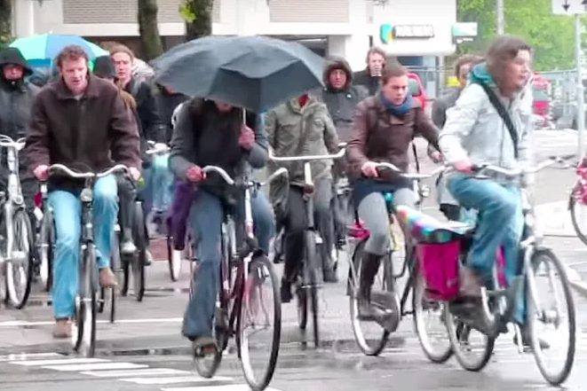
Over time, the city assembled a complete network for cycling (which is also used by the disabled) — but not without slowing and curtailing space for driving. Now, by design, driving a car is so inconvenient that it’s faster to bike across the city. Not to mention, the Netherlands is the safest country in the world to ride a bike!
And the city isn’t finished. Through decades of dedication and a recent phenomenon of street experimentation like this one, Amsterdam neighborhoods have achieved a more balanced mobility — lots of everyday cycling, with an average of 40 percent of all trips across the city by bicycle. Even in the most car-friendly neighborhoods, only about a third of all trips are by car.
On our bike tours around Amsterdam, I show students how the city has transformed. By the end of the tours, students — like most delegations who come to the Netherlands to learn about cycling policies — sound discouraged. “We don’t have 40 years to get people out of their cars,” they say. “And we’re not Amsterdam!”
True, no two cities are the same. But just as Amsterdam (and Copenhagen) did in the 1980s and '90s, Seville, Spain, did more recently. With 18 months — and the reallocation of about 5,000 on-street parking spaces — Seville’s bike network was built. It’s not perfect, but it works for commuters, parents, kids, the elderly and the disabled. Paris is reducing city speed limits to 19 mph. Stockholm’s congestion pricing is a success. London has raised funding for bike/pedestrian projects and is building out a network by reallocating road space. I could go on.
American cities are eager, perhaps even compelled, to “learn” from other cities, but there is often pushback: We’re not Seville; we’re not Paris; we’re not Stockholm. We cannot copy and paste.
But it's not about copying what they are doing — reducing vehicle speeds, reducing on-street parking and creating a cohesive network of safe facilities for people walking, cycling or using a wheelchair — but how they are doing it. Local leaders need to first realize ideas are not new.
Certainly, as human beings, we're wired to resist change, and changing mobility habits is especially challenging. So a good starting place is to reframe our questions. Instead of asking, "How do we increase cycling?" let’s ask, "How do we decrease driving?" Instead of, "How do we protect our cyclists?" let’s ask, "How do we slow down people driving cars?" Instead of, "How do we make space for cyclists?" let’s ask, "How do we make space for the majority of people who don't drive?"
In the end, it’s not about bikes and bike lanes — it’s about access to safe streets, public space, and urban life. Can we all, at least, agree on that?
Meredith Glaser (@dutch_ish) is a researcher at the Urban Cycling Institute (University of Amsterdam) studying knowledge and policy transfer of Dutch cycling policies to other parts of the world.
