Connecting Cities’ Scattered Bikeways Is Going to Be Harder, But Worth It
When the low-hanging fruit has all been eaten, there’s only one thing to do: climb higher.
According to a new project from the federally funded Pedestrian and Bicycle Information Center, that’s what’s happening with bike infrastructure in many North American cities. For 20 to 30 years now, many cities have been laying down bike infrastructure where it’s cheap and easy:
- streets with more passing lanes than they really need
- streets whose lanes were striped dangerously wide
- streets that are being built or rebuilt from scratch
This catch-as-catch-can method has left cities with bike networks that look like so many pick-up sticks: better than nothing, but far less intuitive or comfortable than the cities’ driving networks.
Is it any wonder that bike transportation, though growing, remains fairly unusual even in the bike-friendliest big cities?
According to a memo accompanying the project, cities are now looking systematically for possible connections between their existing bikeways.
These examples [in Austin, New York City, Tallahassee, Seattle and Vancouver B.C.] demonstrate the value in shifting away from focus on the “low-hanging fruit” of bike infrastructure – streets with excess auto capacity or unused parking – and toward the most important roads for bicycle connectivity, even if they require difficult tradeoffs. These changes may be more politically difficult, but if chosen well they promise bigger payoffs in ridership and safety.
(Full disclosure: PeopleForBikes contributed this memo to the project ourselves, as a subcontractor for the PBIC.)
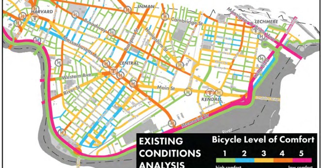
The PBIC is also circulating the Bike Network Mapping Idea Book published last year by the Federal Highway Administration. It includes 23 examples of bike maps of different scales: state, regional, county, city, campus. The book identifies the key features of each map.

This isn’t the sort of bike map you’d use to plan a picnic — it’s the sort that city planners, advocates, and others use to figure out where the existing network is strong, where it’s weak, and what the most valuable new connections might be.
PeopleForBikes is working to make this process a little more quantitative by developing the Bicycle Network Analysis, a numerical score that can be calculated for the current or future biking network in any community. It’ll be one factor in the PlacesForBikes city rating system, but as it develops, we hope it can give local planners the ability to calculate the value of any given parking lane, if only it were to become a protected bike lane instead.
That won’t in itself make it politically easier to remove parking. But it might help cities calculate which such battles will actually result in the best results.
PlacesForBikes is a PeopleForBikes program to help U.S. communities build better biking, faster. You can follow them on Twitter or Facebook or sign up for their weekly news digest about building all-ages biking networks.

Read More:
Streetsblog has migrated to a new comment system. New commenters can register directly in the comments section of any article. Returning commenters: your previous comments and display name have been preserved, but you'll need to reclaim your account by clicking "Forgot your password?" on the sign-in form, entering your email, and following the verification link to set a new password — this is required because passwords could not be carried over during the migration. For questions, contact tips@streetsblog.org.