Berkeley Gets a Protected Intersection
Good bike infrastructure can be simpler and less expensive to build than planners realize. A great example of this just got built in Berkeley, where a Safe Routes to Schools project hit a snag, and in the process of solving the problem got better—and cheaper.
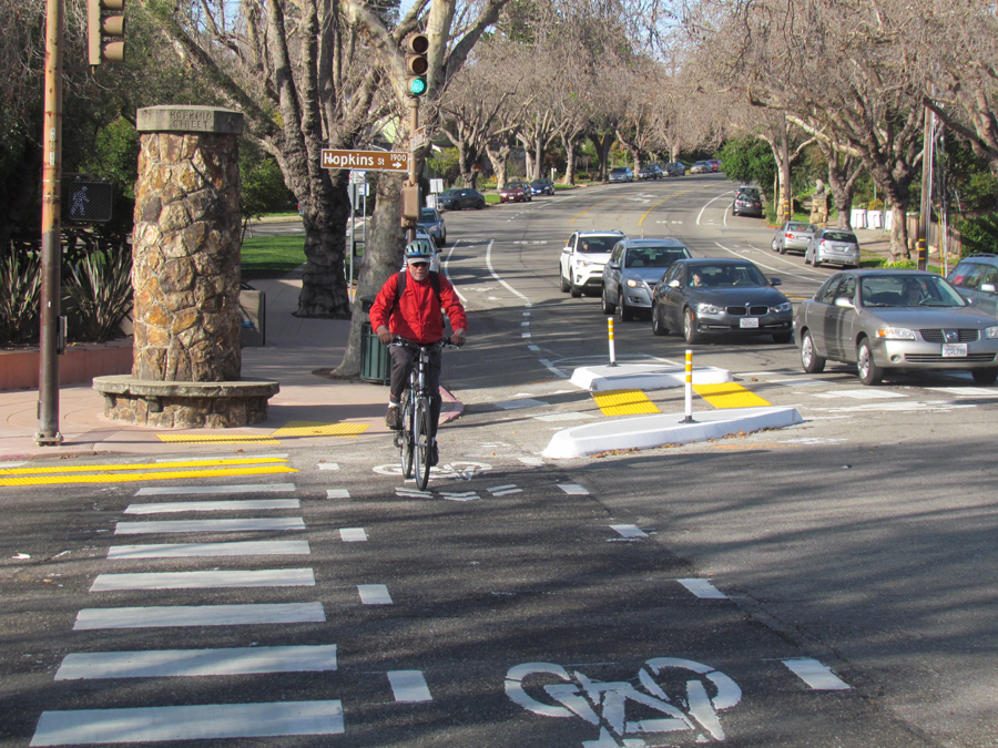
The original project was to add pedestrian bulb-outs at the corner of Hopkins and The Alameda, a wide intersection next to a library and near several schools. The idea was to narrow the crossing distance and in the process get cars navigating the turns to slow down.
The project got state funding in 2010, but was delayed because drainage at that intersection is complicated. The two streets that cross here go up hill and down, and there is a wide crown lifting the center of the intersection higher than the corners.
Engineers had not yet come up with a solution, and the grant had to be spent or it would be rescinded. City staff, who had been thinking about ways to let water drain through the intersection along its existing route—between the curb and the new bulb-outs—realized that if they widened the waterway it could become a protected bike lane.
And voila, for a lot less money—not to mention concrete—than a standard bulb-out, the city created a protected intersection for bikes and pedestrians. New “floating islands” narrow the intersection a bit, forcing right-turning cars to slow down and turn more sharply.
They also shift the angle at which drivers approach the pedestrian crossing and bike path after the turn. That brings bikes and pedestrians more directly in front of the drivers’ field of vision, and thus harder to ignore.
“The city may need to add a flex post or two between the crosswalk and the bike crossing,” said Bike East Bay Advocacy Dave Campbell. “I’ve seen some cars trying to make the shortcut, between the bulb and the corner. They haven’t got used to it yet.”
Campbell said some bike riders have commented that the islands are right in the middle of the path they used to take across the intersection, so that they have to veer outside it, or slightly to the right into the bike lane, and slow down. “The answer is that, yes, you do need to slow down,” said Campbell.
The intersection turned out to be a creative, easily placed way to slow down cars at an intersection that sees a lot of traffic. But it’s not finished yet.
“Ultimately we want to match the intersection with protected bike lanes,” said Campbell. Berkeley, he added, is just beginning to see the value of protected bike lanes, having built one earlier this year along Fulton Street.
I guess this is Berkeley’s interpretation of a Dutch intersection. I live a block away and bicycle everywhere. I will not use these “lanes” when I return southbound from hill rides they require distracting and abrupt island avoidance maneuvers. I expect more vehicular harassment now using the restricted main lane. In the dark the islands are real hazards to people unfamiliar with the intersection, use of channelizers would improve these approaches. I avoid MLK like the plague when cycling except for the last block to my house. There should be better signing recommending use of Bonita or Josephine as an alternative to MLK. Josephine southbound has an excellent approach from The Alameda behind the library but that is not a bike route instead the bike plan shows bikes passing through the Hopkins / The Alameda intersection southbound which leads people to the single lane merge which is a hazard?
The Dutch intersection bike lanes will not be maintained because they are too narrow to street sweep. The geometry is too severe causing distracting and abrupt avoidance maneuvers. It will be very dangerous when wet and debris accumulates, never mind that there is a drainage inlet in the “lane” in the northbound The Alameda direction. We will see what happens but it looks like bad design from my perspective. Things Berkeley should fix is the road surfaces and elimination of parking on the narrow Shattuck southbound lane the first block south of Ashby which is often a point of conflict between cars and bicycles.
I live almost right there and drive through that intersection all the time, and I think it is potentially kind of dangerous. The ‘blobs’ are hard to see for a driver. I know they are there because I watched them building the blobs and I drive by there, but for someone who is not familiar with the setup it is confusing and it would be pretty easy to even run into one of the blobs. I do agree it may be safer for pedestrians though because I also often walk through there and drivers looking left and turning right are hazardous to pedestrians. I think the blobs are too flat and hard to see for a driver though.
my associate who is a member of the bicycle advocacy group here… keeps reminding me that they HATE these stupid changes that solve a non problem.
What they want is recognition that they can use the normal traffic lanes….he agrees that slow traffic has to stay in the right lane (except when making a left turn).
I live near this intersection, and bicycle through it regularly. In my opinion, this new “bike infrastructure” has made the intersection much more dangerous for autos, bicycles, and pedestrians. I’m amazed to see articles praising it. The problem is that the concrete blobs have changed a standard intersection into a very weird one, requiring unexpected sudden route changes. It is the weirdness that makes the new layout dangerous. Auto drivers and bikers are both confused and distracted by the blobs, and end up making sudden lane changes. Cars that start moving right, in order to make a right turn on red, find their way blocked and end up suddenly merging back to the left. Bikes are confronted by concrete blobs sitting directly in the paths of the original bike lanes, and must suddenly pick a new path — either through the very narrow, twisty “protected” route between the blobs, or out in the traffic lane. I don’t think these sudden lane changes are making life safer for the pedestrians, either. Certainly the concrete blobs are not safe islands — I have seen SUV’s drive directly over the blobs. This project took an intersection that was not particularly dangerous, and turned it into a nightmare. I predict that there will be more accidents as a result, and sooner or later the blobs will be removed.
We should have the Quirky Berkeley fellow do an essay on local/code-mandated street markings. On many streets, we meander by law..
The photos poorly illustrate the hazard of these curb chicanes, especially in the eastbound direction. It is not obvious how much cyclists must slow in order to safely negotiate these oddly placed curbs. This may be ok for those riding less than 10mph (5mph for cargo bikes) but the rest of us will be staying in the auto lane even though that means harassment from motorists who now expect us to get off of the road and use the ‘protected’ lanes. These hazards will be amplified at night due to the intersection’s poor lighting. Nowhere are there sharrows or signs reminding motorists that cyclists still have the right to use the lane, a lane which having been narrowed will now need to be ‘taken’ by riding down the middle to discourage motorists from sharing where there is insufficient room to do so safely. More of a ‘problem is Dave Campbell’s comments “yes, you do need to slow down” indicating a bias favoring slow cyclists. Considering motorists and peds will not need to slow down how is this consistent with bicycle advocacy? It is unfortunate this money wasn’t spent fixing Hopkins St pavement. That would have been much more effective in terms of bicycle safety.
Looks palatable, but the outside turn radius is still rather wide. Also, has R10-15(modified) signage been applied on the approaches? That’s extremely critical since it appears that separate signaling is not in use here. Otherwise, someone is bound to get hurt, especially since the turn radius is still so wide. https://uploads.disquscdn.com/images/db578580754662cc493d663256dcf08fa75a727720d4e5f71af7109b57245e86.jpg
After about a month of construction, the result is taking a lot of time to learn…suggest City of Berkeley communicate with UC whose employees are so keen to leave our city starting at about 4pm via this route. Many misunderstandings….and honking horms. Pity the cyclists and pedestrians who try to negotiate this route.
There are some curbside bus stops in the area where Berkeley dashes bike lanes to indicate the crossing area, however in top photo I think that southbound dashed lane line is actually a contractor striping error as the schematic shows the dashed lane line in the northbound direction only. I will be following up with city staff to make sure this is on their radar. https://uploads.disquscdn.com/images/a66aaaec7ddc67689c6cec1719de187c48fce6ef95e28b6dda32a22475a9dd34.png
Just a guess, but the city probably left the dashed line there as a peace offering to vehicular cyclists who wanted a legal way out of using the protected path. The end result is something that confuses drivers – as you say – and ultimately creates a more dangerous situation. Typical VC “advocacy” at work.
The striping before the island indicates that cars should merge into the bike lane, so I can understand why drivers thought it was a turn lane