Metro Looks to Widen the 14 Freeway in North Los Angeles County
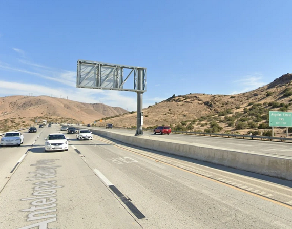
Last week the Metro board approved a motion that directed Metro staff to work with Caltrans “to correct sub-standard configurations” on the 14 Freeway in North L.A. County. In L.A. freeway-speak, “correcting sub-standard conditions” pretty much always means widening the freeway. The motion pretty much confirms this, noting that “the [SR-14’s] sub-standard lane drop configuration creates bottlenecks.” How have Metro and Caltrans dealt with lane drops and bottlenecks in the past? They have added more lanes.
The motion was authored by Metro Board Chair Ara Najarian, alongside Boardmembers Kathryn Barger and James Butts. In committee [minute 36], Najarian urged motion approval noting how the main problems are many locations with the 14 Freeway “going from three lanes to two, especially with a downhill and very curvy route.” He called “to keep the lanes at their most optimal configuration” and he was not suggesting that the three lane sections to be reduced to two lanes.
Note that Najarian’s numbers refer to just one direction – and omit existing carpool lanes. There are no curvy hilly “two lane” [four total lanes] stretches of the SR-14. (The only L.A. County stretch of “two lane” [four lane total] 14 Freeway is flat and straight, from the northern part of Lancaster to the Kern County Line.) Through Santa Clarita, and northeast of Santa Clarita to the Antelope Valley, where the 14 is hilly and curvy, the narrowest parts of the 14 Freeway are already at least three lanes wide [six-plus lanes total]; each direction has at least two general purpose lanes alongside a carpool lane.
The motion called for acting on recommendations in the 2004 North County Combined Highway Corridors Study. That study called for increased transit, multiple reversible high-occupancy lanes, and lots of “substantially increased vehicle capacity.” It calls for 14 Freeway “short-range improvements” to include “elimination of lane drops with continuous 3 mixed-flow lanes and one HOV lane in each direction between Sand Canyon and Avenue P.”
The distance from Sand Canyon to Avenue P is about 25 miles. The lane configuration there varies; most of it is six lanes wide, with some seven and eight lane stretches.
Caltrans had indicated its plans to initiate a “capacity improvements” project on about thirteen miles of SR-14 (between Newhall Avenue and Agua Dulce Canyon Road) in 2022. About seven miles of that overlap with the short-range SR-14 widening in the 2004 report. The status of that overlapping project is unclear; it does not appear on the Caltrans District 7 current projects listing nor the California Environmental Quality Act (CEQA) database.
The motion directed Metro staff to get environmental clearance underway for three substandard locations on the 14 Freeway, utilizing $4.7 million in funding from the North County Transportation Coalition. Starting in October 2022, Metro staff will report back to the board with the status of this project.

Streetsblog has migrated to a new comment system. New commenters can register directly in the comments section of any article. Returning commenters: your previous comments and display name have been preserved, but you'll need to reclaim your account by clicking "Forgot your password?" on the sign-in form, entering your email, and following the verification link to set a new password — this is required because passwords could not be carried over during the migration. For questions, contact tips@streetsblog.org.