A Simple Change to Make the Walk to Transit Feel Within Reach
Sometimes, high-quality transit is within a walkable distance, but people just aren’t used to walking to the train. New signage in St. Paul, Minnesota, funded through a local challenge from a national foundation, aims to help people get over that mental block and walking to the nearest Green Line station.
The light rail line opened in June 2014, connecting Minneapolis and St. Paul with rail transit for the first time in more than 60 years. But many of the neighborhoods that the line runs through, along University Avenue, have struggled with disinvestment during that time. The new light rail line is a big improvement in access for those neighborhoods, but it’s only one part of the solution.
With that in mind, the Knight Foundation and The Saint Paul Foundation launched the Green Line Challenge, a three-year, $1.5 million grant program that challenges local residents and organizations to come up with small ideas that “tap into the potential of the Green Line” and impact the surrounding neighborhoods. Each year, about a dozen winners are selected and given small grants from an annual pot of $500,000.
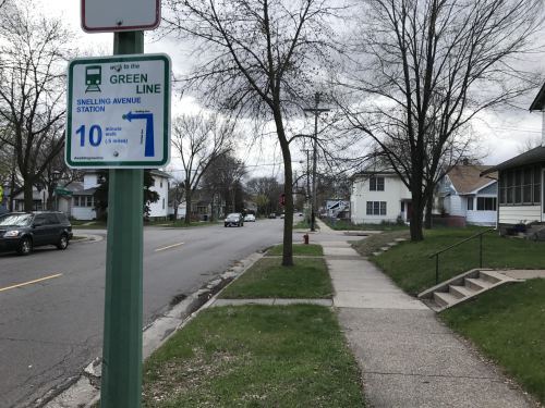
Matt Privratsky, who lives a little over a mile south of the Green Line, often found himself taking the bus rather than walking to the station, which sits on the other side of Interstate 94 and near a group of big-box stores. He writes about the problem in Streets.mn:
I quickly realized that part of the challenge might be that the walk to the train feels much farther and more daunting than a mile… As I was riding the bus one day (rather than walking) I saw a tweet about the Knight Foundation’s Green Line Challenge and decided to submit a roughly 100 word application for a project that might help.
His idea was to install signs throughout the neighborhood telling people how long it takes to walk to the nearest Green Line station and giving directions there. After working with representatives from community councils and the city, about 175 signs were designed, fabricated, and are in the process of being installed at a cost of $23,250. The entire project, from the time it was awarded funds to getting signs on the street, took a little over a year.
Privratsky said the Knight Foundation deserves credit for making it easy for people to suggest ideas through the Green Line Challenge. “The super simple first application means more ideas make it through the first phase,” he said. “It’s a very unique approach.”
Ultimately, though, Privratsky has a simple goal: “I hope the signs help you #WalkTheGreenLine,” he wrote.

Streetsblog has migrated to a new comment system. New commenters can register directly in the comments section of any article. Returning commenters: your previous comments and display name have been preserved, but you'll need to reclaim your account by clicking "Forgot your password?" on the sign-in form, entering your email, and following the verification link to set a new password — this is required because passwords could not be carried over during the migration. For questions, contact tips@streetsblog.org.