The People Left Behind By Car-Centric Planning
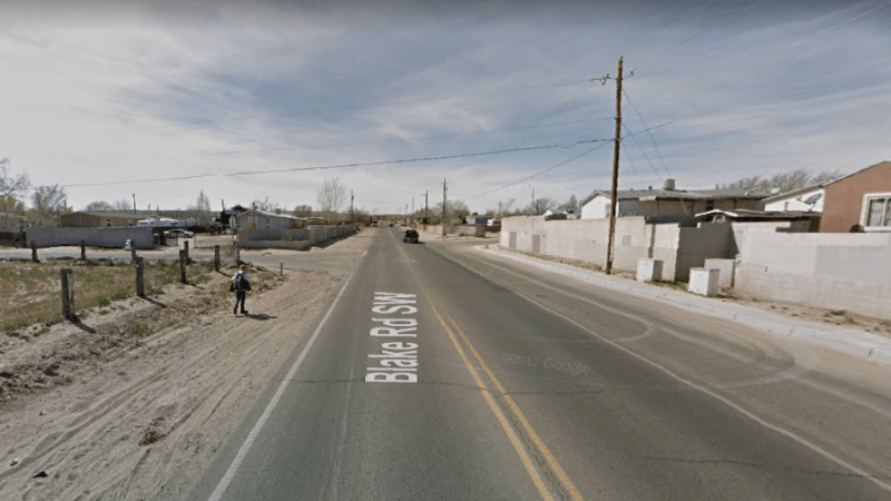
The child walking in the dirt along this high-speed road in Albuquerque isn’t the type of person America has designed its transportation systems for.
Engineering formulas and public budgets typically focus on eliminating delay for motorists. A kid walking to school is an afterthought, or worse, an inconvenience in a system that aspires to scientific efficiency in moving cars.
The writers at Better Burque flagged this Google Street View photo as an example of how the city and county should be doing better for people on foot. It’s no surprise that a child is walking here:
There are five schools within a one-mile radius here, and many trailer parks, including the one noticeable in this Google Street View. One school, Robert F. Kennedy Charter, is mere feet from this kid.
Despite the obvious failure to design this street so kids can safely walk to school, when drivers harm pedestrians in this type of environment, it’s the victim who gets blamed. A few lines appear in the local paper failing to note anything about the configuration of the street or the driver’s behavior, and that’s the end of it. Patterns of preventable deaths resulting from known design flaws are treated as isolated tragedies we have no control over.
But car-centric roads and land use patterns endanger people on foot every day. They’re captured all the time in photos like this one in Nashville:
It is cruel that we do this to people. And then if they’re killed we blame them.
Photo: @norakernel @walkbikenash pic.twitter.com/G2QjMlLDjS
— Streetsblog USA (@StreetsblogUSA) November 14, 2017
More people need to see what a hostile environment we’ve made for people outside of cars, so we’re going to do a crowdsourcing project. Do you have photos of people trying to navigate dangerous situations on foot? Either your own work or pulled from Google Maps? Send your images to angie [at] streetsblog [dot] org or tag them on Twitter with #walkinginthemargins.
More recommended reading today: PlanPhilly writes that job sprawl is part of what’s keeping many central Philadelphia residents mired in deep poverty. And Seattle Transit Blog explains how the region’s new transit fare card will work.

Streetsblog has migrated to a new comment system. New commenters can register directly in the comments section of any article. Returning commenters: your previous comments and display name have been preserved, but you'll need to reclaim your account by clicking "Forgot your password?" on the sign-in form, entering your email, and following the verification link to set a new password — this is required because passwords could not be carried over during the migration. For questions, contact tips@streetsblog.org.