Plans Advance for Bay Bridge Bike/Ped Path to San Francisco
Note: GJEL Accident Attorneys regularly sponsors coverage on Streetsblog San Francisco and Streetsblog California. Unless noted in the story, GJEL Accident Attorneys is not consulted for the content or editorial direction of the sponsored content.
A preferred design for a bike and pedestrian path on the western span of the Oakland Bay Bridge will be presented to the public next month, according to a statement from the Bay Area Toll Authority (BATA), Caltrans, and a team of engineers and consultants working on the project.
From the team’s announcement:
The preferred design alternative, developed in 2018, will be presented to the public on November 19. It features an alignment running along the north side of the West Span [between Yerba Buena Island and San Francisco] with a touchdown in San Francisco at Essex Street (parallel to First and Second streets, between Folsom to the north and Harrison to the south). The recommendation for the Yerba Buena Island connection joins the East Span path via Southgate Road along the east side of Hillcrest Road. The path would share architectural features with the East Span path, providing continuity of experience along the entire crossing.
The more fanciful but expensive alternatives, such as a path suspended over the current roadway (see image below) were dropped for a variety of reasons, including cost and complexity.
“The north side has always been preferred because of the views,” said Dave Campbell, advocacy director for Bike East Bay, which is pushing to get funds from MTC for engineering studies for the path and to “fund construction of the Yerba Buena Island piece of this.”
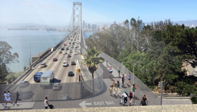
The plan, he explained, is to have a path that loops around from the now-complete eastern span bike path, crosses over the western span on Yerba Buena (as seen in the lead photo) and then connects to both the future western span bike and ped path and a ramp down to Treasure Island. The connection between the spans is expected to be relatively level. “We want to fund construction of this piece because it has independent utility; it will connect you to the island and the new ferry service that will be operating long before we ever get the west span path built,” he added.
According to the San Francisco Bicycle Coalition, some 10,000 people are expected to bike the Bay Bridge daily. “The path for people biking and walking the Bay Bridge’s West Span represents not only an architectural accomplishment to bridge two cities separated by a bay, but also one of practical need,” wrote Janice Li, Advocacy Director for the San Francisco Bicycle Coalition, in a post about the project in 2016. She added that as “housing and commercial developments on Treasure Island are built out” there will be even more demand for bike connections.
“What has been a long-held dream for generations of Bay Area residents is now one step closer to reality. The designs for the Western Span People Path powerfully illustrate the impact of this project, with real potential to alleviate crowding on BART and congestion on the Bay Bridge,” wrote the SFBC’s Brian Wiedenmeier, in an email to Streetsblog.
Of course, the biggest challenge for the western span path hasn’t changed over the years and is made plain again in MTC’s statement: “Estimated costs for a project of this type run into the hundreds of millions of dollars. No source of funding has yet been identified,” they write.
For those not from the Bay Area, a bike and pedestrian path opened on the new eastern span of the Bay Bridge in 2013. However, it ends halfway across the Bay at Yerba Buena Island. There is currently no way to bike or walk (at least not legally) from Oakland to San Francisco. Proposals for a bike and pedestrian facility on the western span have been bandied about for decades.
To get a first-hand look at the preferred design, join the West Span Bike + Pedestrian Path Public Meeting #2 on Monday, Nov. 19, from 6-8 p.m. at the Bay Area Metro Center, 375 Beale Street, S.F. The meeting will feature a presentation, a question-and-answer session, interactive workstations, and virtual reality goggles so you can ‘stand’ on the proposed path and look at the design in three dimensions.
RSVP/register for the meeting here.

Streetsblog has migrated to a new comment system. New commenters can register directly in the comments section of any article. Returning commenters: your previous comments and display name have been preserved, but you'll need to reclaim your account by clicking "Forgot your password?" on the sign-in form, entering your email, and following the verification link to set a new password — this is required because passwords could not be carried over during the migration. For questions, contact tips@streetsblog.org.