Note: GJEL Accident Attorneys regularly sponsors coverage on Streetsblog San Francisco and Streetsblog California. Unless noted in the story, GJEL Accident Attorneys is not consulted for the content or editorial direction of the sponsored content.
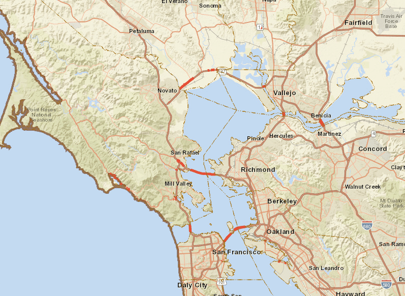
Caltrans just released its first report on the vulnerability of the state highway system to the effects of climate change. This report focuses on Caltrans District 4, which covers the greater Bay Area, from Santa Rosa to Gilroy and including part of the Sacramento River Delta. Caltrans expects to eventually produce a similar study for each of its twelve districts.
The intention of the study is “to provide data to support the discussion about how climate change impacts the way we plan, design, build, operate and maintain the state highway system,” according to Caltrans director Malcolm Dougherty.
The report does not propose specific projects, nor discuss costs. Instead, it uses the best science currently available—estimates from the Intergovernmental Panel on Climate Change (IPCC) on potential temperature changes and sea level rise—to assess the various types of risk the state will need to prepare for in the future. It studies which state highways are most vulnerable to flooding and other damage, assesses possible consequences, and evaluates methods for deciding how to prioritize action.
The District 4 report looks at Bay Area state highways that are vulnerable to rising sea levels and storm surges, changing rain patterns, wildfires, and increasing temperatures associated with climate change. Possible consequences to the state highway system from high temperatures, for example, include increased pavement failure and thus maintenance costs, dangerously hot working conditions for employees, the need for shelter for people waiting for transit, and landscaping that has to be able to survive longer periods of higher temperatures.
In last year's storm season alone, California experienced severe flooding, landslides, and coastal erosion that cost the state over $1 billion in highway damages statewide. Almost $400 million of that occurred in District 4.
The overall intent of the report, it says, “is to add some definition to a subject with many unknowns (climate change), and begin to define a subset of assets from along the State Highway System that will be addressed” in the future.
A summary report provides a quick primer on the consequences of rising temperatures and shifts in rain patterns to infrastructure in general. It uses IPCC estimates of three different potential sea level increases to discuss possible consequences to Bay Area roads and bridges. The report only discusses Caltrans' highways, not the many local streets and roads in the district that may also be subject to flooding or other effects of climate change.
It found that about 95 miles of Caltrans roads and bridges may be subject to flooding from sea level rise by the end of the century, and about 110 miles of those highways are subject to storm surges.
A technical report, providing a more detailed discussion of the issues, is also available to the public, although it is intended mostly for Caltrans staff.
The report is also accompanied by an interactive map showing exactly where the vulnerable roads and bridges are located within the district.